
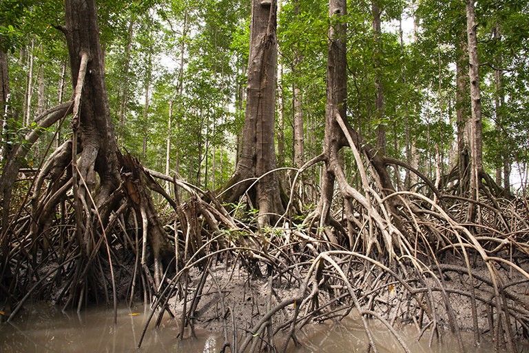
Finland’s Kuva Space and World Wildlife Fund (WWF)-Indonesia have launched a first-of-its-kind effort to test whether hyperspectral satellite data can reliably measure how much carbon is stored in Indonesia’s mangrove and seagrass ecosystems.
The collaboration, announced today, positions Indonesia—home to roughly one-fifth of the world’s mangroves—as a high-stakes proving ground for replacing time and labor intensive field surveys with satellite monitoring. The partnership is also among the earliest efforts to determine whether space-based measurements can meet the rigorous standards required for national climate reporting and climate finance markets.
Verification bottleneck: Blue-carbon ecosystems, such as mangroves, seagrasses and salt marshes, are among the most efficient natural carbon sinks—or environments that store large amounts of carbon, which helps to slow climate change.
Yet credits for protecting or restoring these ecosystems make up only 0.91% of the voluntary carbon market, largely because measuring their carbon stores remains a slow, fragmented, and costly process.
Remote sensing advances are rapidly improving transparency and verification, advocates say—which is critical for scaling climate finance. Hyperspectral imaging can identify species, estimate plant mass, and measure carbon in far more detail than traditional satellites or field surveys, and offers a promising path to more credible and consistent measurements.
Eyes in space: Kuva Space will use its hyperspectral satellite constellation and AI-driven analytics platform to map mangrove and seagrass ecosystems across sites in East Nusa Tenggara and East Kalimantan. The collaboration is set to begin in early 2026 and continue through 2027, Kuva Space CEO Jarkko Antila told Payload.
“Essentially, we’re making a dashboard that keeps a pulse on the coastal ecosystem, like no other tool out there,” he said.
Exclusive: SpaceComputer and Spacemanic Partner on Security Demo Mission
Space Fabric is SpaceComputer’s solution not only for the growing hacking threats on-orbit, but also for the increasing number of shared-compute modules operating on rideshare sats.
Japan Eyes Sovereign D2D Satellite Network
Japan plans to select a proposal this month for its domestically owned and operated D2D satellite network, called J-LEO.

Ubotica Raises $11M for Satellite-Based AI Tech
The Dublin-based space AI company raised $11M today to accelerate the commercialization of its AI-powered intelligence platform for maritime security.
ElevationSpace Closes $40M Series B
The Japanese satellite reentry startup raised a $40M Series B, bringing the company’s total amount raised to $63.5M.

Geospatial intelligence startup Wherobots launched a new product today—called RasterFlow—aimed at making EO data more accessible.
The volume of EO images has grown exponentially the past decade, but cleaning up, deciphering, and extracting value from these datasets remains manual, expensive, and time-consuming, according to Wherobots officials.
“There isn’t actually a real platform that exists out there that can automatically detect, classify, and understand what’s happening within this imagery,” Wherobots CEO Mo Sarwat told Payload. “AI doesn’t understand the real world…So RasterFlow is going to bring that understanding of the physical world to AI agents.”
Keep reading