
ICEYE just one-upped the Lorax. Instead of speaking for the trees, the SAR satellite manufacturer is letting the trees speak for themselves.
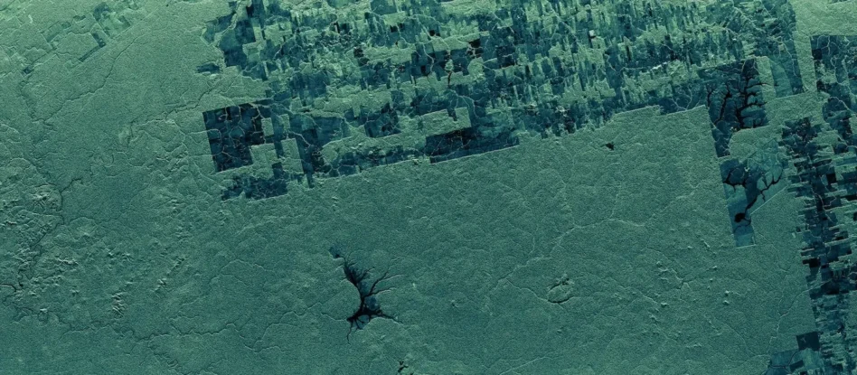
ICEYE announced the launch yesterday of a new deforestation monitoring tool, which uses SAR imaging to provide near-real-time insights into illegal deforestation of the world’s largest rainforests.
Going under cover: Traditional optical satellites have spotted the results of illegal deforestation from space for years, in places like the Amazon. Traditional optical EO capabilities, however, struggle to uncover deforestation while it’s in progress. Essentially, rainforests like the Amazon are so dense that they generate their own cloud cover. It’s estimated that the Amazon experiences cloud cover for about 66% of the year on average.
This near-constant cloudy weather allows wood poachers to deforest parts of the rainforest clandestinely, with researchers only discovering loss once the clouds dissipate.
With SAR imagery, ICEYE can see through the clouds to detect deforestation as it’s happening, giving local governments a better chance at apprehending and stopping illegal activity before losses become widespread.
“When forests are under threat, timing is everything,” Andy Read, ICYE’s VP of government solutions, said in a statement. “SAR removes the blind spots that have historically limited monitoring, and enables a continuous stream of trusted intelligence.”
I spy: ICEYE’s deforestation tool isn’t just monitoring the situation. It’s built to quickly identify newly cleared parcels. The tool is also integrated with ground operations to verify permits, potentially allowing lawmakers to swiftly halt illegal, non-permitted activity.
Today, the tool covers the Amazon Basin, but future regions will include the Congo Basin and the Southeast Asian Archipelago Rainforest. At a time when the planet needs its trees more than ever, ICEYE’s new tool aims to give a leg up to those speaking on behalf of threatened climates.
“Illegal mining and deforestation are accelerating in remote regions. Access to near real-time, cloud-penetrating data strengthens our ability to document impacts, prioritize threats, and advocate for immediate action,” Lilian Pintea, VP of conservation science at the Jane Goodall Institute, said in the same statement.
Europe Expands its Launch Opportunities to New Companies
European launch demand just got a boost.
Optera Raises £3M to Open New UK HQ
The funding round comes amid the UK government’s full-court press to expand its sovereign technical capabilities.
What the SpaceX IPO Means for Europe’s Space Industry
All eyes are on New York today for SpaceX’s IPO, but the moment represents more than just a record-breaking exit by a US space company.
Exclusive: Tilebox Launches AI-Focused Update
Tilebox announced an update today aiming to make AI agents more effective geospatial-data analysts.

Military officials often repeat that space is now a contested domain. There’s just one problem—the US service tasked with space operations isn’t ready to operate in a contested in-orbit environment, according to a conservative think tank.
The Heritage Foundation released its annual Index of US Military Strength on Tuesday, and the Space Force overall received poor marks.
“The Space Force is woefully short of the resources required to hold adversary space systems at risk, and is not ready to operate in a contested environment even though conflict with a major adversary will likely begin in space,” the report says. “While most of its current capabilities are highly effective in an uncontested environment, the Space Force lacks the capacity and capability to be ready for conflict in space.”
Keep reading