
Wildfires are burning through balance sheets—and OroraTech wants insurers to stop getting scorched.
The US subsidiary of the German satellite startup inked a partnership with risk intelligence platform Opterrix to bring near real-time wildfire data into insurers’ risk platforms. The first pilot customer? USAA.
“Opterrix is on the cutting edge for visualizing risk for insurers, and we are on the cutting edge of determining wildfire risk—the integration just makes sense,” Thomas Gruebler, OroraTech co-founder and chief executive of OroraTech USA, told Payload.
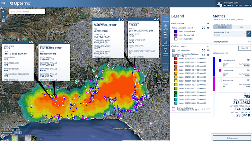
Through the partnership—which marks OroraTech’s first foray into insurance—Opterrix users can see active wildfire threats near policyholders in real time, powered by OroraTech’s thermal-infrared satellites and proprietary Fire Spread modeling, Gruebler said. “This enhanced visibility supports more informed underwriting, faster claims response, and more accurate risk modeling,” he said.
The monetary value of the agreement was not disclosed.
Why it matters: With insurers facing billions in wildfire-related losses each year, this partnership aims to turn reactive claims into proactive decisions, Gruebler said. Most carriers still rely on fragmented, or delayed, third-party data. OroraTech controls its own space-based sensors, fusing orbital feeds with public datasets to build one of the most comprehensive wildfire monitoring systems around, he added.
State-side strategy: OroraTech expanded its operations to Colorado in April, eyeing the US as a critical growth market. “The US presents one of the most urgent and complex wildfire risk profiles globally due to the interplay of hotter weather, land-use patterns, and drought conditions,” Gruebler said. “Expanding into this market is both a natural step for OroraTech, and a necessary one.”
What’s next: OroraTech’s first proprietary satellite constellation, Pine Grove, formerly known as OCT-P1, will become fully operational, enabling real-time thermal imaging with improved frequency and precision, Gruebler said. Later this year, the startup plans to launch a second constellation of eight satellites to enhance OroraTech’s global coverage and revisit rates, he added.
“Five years from now, we see OroraTech as a foundational layer in the global climate resilience infrastructure,” said Gruebler. “Our goal is to make high-resolution, real-time thermal imaging as accessible and indispensable as GPS is today, powering smarter decisions across sectors.”

Voyager and Icarus Team Up on ISS Robotics Demo
The pages of the ISS manifest are starting to look a lot like those of a sci-fi novel.
Transporter-16 Sends 119 Payloads to Orbit
The latest cargo train to orbit has left the station.

Starcloud Raises $170M Series A at $1.1B Valuation
The fundraise highlights not only the overwhelming demand among investors to fund orbital-data-center ventures, but also Starcloud’s unique position as a data-center startup with flight heritage.

Xona Space Systems Raises $170M Series C to Scale Private GPS
Xona has spent the past few years building its ability to transmit PNT signals in LEO that are stronger, more accurate, and more secure than traditional GPS.

There’s a light at the end of the tunnel for French commuters frustrated that their WiFi keeps dropping out over the countryside.
The French national railway company (SNCF) is planning on releasing a tender to integrate satcom-enabled connectivity throughout its train fleet. Many in the industry assume that the decision will come down to SpaceX’s Starlink, or France’s Eutelsat OneWeb.
While SpaceX did not respond to a request for comment, Eutelsat shared some of the details with Payload of why it thinks it’s the best company for the job.
Keep reading