

Satellogic (NASDAQ:SATL) has signed a multiple launch agreement (MLA) with SpaceX covering the deployment of 68 new Earth observation (EO) satellites.
The freshly inked MLA succeeds Satellogic’s current one covering 2022 SpaceX launches. On April 1, SpaceX launched five Satellogic satellites to a sun-synchronous orbit on the Transporter-4 rideshare mission.
Satellogic says the launch deals put its constellation on pace to achieve weekly world remaps in 2023. The EO company aims to reach daily remaps by 2025 with a constellation of 200+ satellites. It currently operates a constellation of 22 satellites.
Year in review
Yesterday, Satellogic announced financial results for 2021. The company lost ~$118M on ~$4M in revenue. 2021 was the first year Satellogic began selling imagery. In 2020, while still prerevenue, Satellogic lost ~$114M. Nobody said building a constellation would be cheap…
Balance sheet: At the end of 2021, Satellogic had ~$8.5M in cash/equivalents. But take that snapshot in time with a grain of salt: In January, after a delay, Satellogic SPAC’d and pulled in ~$262M in gross proceeds (with $168M added to the balance sheet).
The company currently has a $816M market cap.
On SPACs…
“Look, it’s a tough market, and we knew that when we closed the transaction,” Satellogic CEO Emiliano Kargieman told Payload in an April interview. “Even though we’re a very capital-efficient company, we’re still capital-intensive. Being a public company gives us a lot of tools that we didn’t have as a private company, to build the company that we want.”
We also spoke with Kargieman about the buildout of Satellogic’s constellation, its daily remap north star, being a “data company,” and technology tailwinds. Find the full interview, which has been edited for clarity and length, below.
Your mission, if I’m not mistaken, is creating a live catalog of Earth and doing so on a daily basis and global scale. What’s the purpose of that?
It’s about democratizing access towards observation, right? The word has been overused a bit. But if you look at the way we collect data, whether it’s satellites, drones, or phones, it’s all very expensive and difficult to scale. If you’re a company operating globally and you want to know what’s going on somewhere else, you build networks of people you can call on the phone, ask to measure something, and report back.
You fly drones, or helicopters, or point imaging satellites. All of those things have an inherent operations cost that is high, but they also have a high opportunity cost. You’re pointing a satellite somewhere, but not somewhere else. You’re flying a drone on one path, and not somewhere else.
In the end, the cost of delivering this data to users has a lower boundary. It’s expensive and has basically created a huge limitation for the kind of applications you can build that use the information.
The question is: How do you solve this problem and create a system that allows everybody to use the data that they need at a price they can pay?
So that’s the democratizing part. Where do satellites fit in?
Turns out you can do it with satellites. What you need to do is to build the infrastructure to go and remap the entire surface of the planet. If we have a daily catalog—or daily remap of Earth’s surface every single day—we can deliver this data to practitioners at the right price point and solve for most applications for observation. And we can replace a large variety of means of data collection that are very inefficient, expensive, and difficult to scale. That was the vision when I started a company a little bit over 11 years ago.
You’ve been at it for a while.
Back then, the question was: ‘Ok, humanity knows how to build high-resolution imaging satellites and put them into orbit. How do we put up 300 or 250 for daily remapping of the entire planet’s surface?’ At the time, if you thought about doing this in a naïve way, you would have had to spend one hundred billion dollars in capex.
And you don’t have that much money laying around.
That’s what took us 10 years: designing the technology and the processes to build this satellite at the right price point with enough capacity, so that we can realize this vision. We’re building satellites that are a little bit less than a million dollars apiece to put in orbit. They can collect data at 70 cm continuously. If we put over 200 in orbit, we will have a daily remap of the entire service of Earth. And we can do that with a capex less than $200 million.
So, for the first time in history, humanity has the technology at the right price point and unit economics to build this infrastructure.
On cost curves, there’s a few elements that everyone points to but I’d like to hear your version. What are the key enablers for Satellogic’s business?
We’re riding a lot of technology trends: standardization of launch interfaces, lower cost per kilogram of launch, computer-aided design and testing, rapid manufacturing capabilities, and the growth of the commercial electronics industry. We can use parts built from laptops and put them in satellites. There’s also the revolution in machine learning, since about 2012, that we can leverage to process all this data. Finally, there’s increasing alternatives for downloading and ground stations.
For EO, there’s two things in particular:
- How do you build a small satellite that collects high-resolution imagery without limiting its capacity to only a few pictures per orbit? This is a difficult technical and scientific problem we’ve solved. We’ve built this camera technology with a small aperture—or a small telescope, basically—without having to pay any of the traditional tradeoffs.
- On top of that, vertical integration. If you’re going out and buying all your components, not only are you dependent on supply chains, you will really delay your development and launch cycles. And it’s a lot more expensive than just building the technology yourself. So, for us, vertical integration accounts for a 10X reduction of costs.
Can you tell me about your experience with Ukraine Observer?
We’re taking the daily collections we’re doing over Ukraine and putting them on Astraea’s platform, so that humanitarian organizations can access it basically in real-time. That can help guide efforts on the ground to get people out, to get stuff into places, to support monetarily, and so on.
It’s been a great experience being able to close this partnership so quickly. We can quickly input data in a format that’s accessible for humanitarian organizations.
For us, it’s a way to make use of this daily “deck” of collections we have in the area, and make it available to a wider audience. We had been working for a while with government organizations, allies, and the Ukrainian government. But this partnership really allowed us to increase the scope and save more Ukrainian lives.
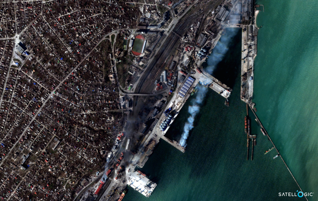
Are there unique challenges to imaging over Ukraine, from a capacity standpoint or weather?
For an event this long-duration, it’s kind of the first time that commercial satellite imagery companies are in a position to provide, support, and scale. It’s a learning experience for everyone. For us, it’s been a good opportunity to optimize for latency. That’s one of the most important things: not only collecting but quickly getting it into the right hands.
Imaging from orbit, following truck changes, and monitoring over a large area—that’s what we do. That’s what the company’s being set up to do, so that has not changed a lot. But how to put this data in the hands of a lot more people a lot quicker—that’s where we’re learning.
Would you say that at scale there’s a compounding advantage to imaging from orbit? Is there a moat in building out the constellation and archive?
Over time, definitely, I would say this is 100% the case. We see ourselves as a data company, not a satellite company. We use satellites but we’re trying to build a live catalog of everything that’s happening. There’s clearly a compounding effect there with a long archive of data. You can train algorithms better and go back in time to understand things that happened in the past.
That’s more important as we launch more satellites. Longer term, as a data company, we have 22 satellites in orbit we’re operating today. We’re still in the old world where we have to point the satellites. Every time the satellites go over Ukraine, for example, we have to pick which points we’ll collect. What we’re looking forward to is when we have this minimum corpus of data we’re generating every day, or even every week to start. That enables you to do things we cannot do today, like searches.
So, we’re still in this old paradigm where we’re pointing satellites and someone needs to decide: ‘Where do we point?’ A small number of countries, companies, and governments make those decisions. Real democratization is when everyone can see what they want.
How exactly do you define democratization? It’s hard to imagine that a lot of this data would be at the fingertips of a billion consumers. Is it more so in how the information is used? Or, expanding beyond the usual suspects you’ve just mentioned?
I think democratization is really about the information that’s collected ending up in the hands of everyone. Now, that doesn’t mean that people will be trained to look at satellite imagery and figure out what’s going on. That’s not going to happen. I mean, nobody cares, right? In the early days of Google Maps, everybody was looking at the satellite overlay. Now, nobody does.
But think about a complete map of the entire Earth that’s updated every day, with semantic information about what’s going on. You can ask questions: Where are the ships now? Where are the new buildings? Who’s building a new swimming pool? How many trees were cut yesterday?
This, I think, is very powerful and will enable new applications to be built. I think those applications will make their way into the hands of billions of people around the world. It’s not going to be the data feeds or even the value-added layers on top. It will be the applications that developers build on top of that data.
Even today, how does your phone know where you are? Most people won’t be able to say that it’s actually due to a few satellites orbiting the Earth in MEO. Nobody really thinks about GPS in those terms anymore. It’s kind of just a function on your phone.
Our goal, then, is blending this kind of information completely into the background, so that it is being used every day to make decisions. By governments, corporations, small companies, or and individuals, maybe without them realizing or knowing what they’re using.
Hindsight is 20/20, but given the broader market outlook, would you have changed your decision to go public via SPAC? Or are you happy with how things went?
Look, it’s a tough market, and we knew that when we closed the transaction. We could have chosen not to. We decided to do this because we think it’s the right path forward for us.
Even though we’re a very capital-efficient company, we’re still capital-intensive. Being a public company gives us a lot of tools that we didn’t have as a private company, to build the company that we want.
At the same time, I think it’s really good in general that the EO companies are going public. We’re opening the businesses to public scrutiny, and we must go out and deliver on the promises we’ve been making for so long. I think it will be very good for the industry overall.

Starship Sticks the Water Landing on Flight 13
SpaceX flew the 13th test flight of its Starship rocket Friday evening, ending with the first intact Starship put in the water.

Intel Authorization Act Proposes Limiting Commercial EO Access
EO data is a privilege, not a right, and the US government wants to control what EO satellite operators can and can’t share with the public.

Skyroot Aerospace Reaches Orbit with Vikram-1 Rocket
Skyroot Aerospace became the first private Indian company to reach orbit on Saturday, when its Vikram-1 rocket lifted off from India’s primary spaceport—the Satish Dhawan Space Centre.

DoD Adds $11.4B to NatSec Launch Contracts
The DoD upped its ceiling for national security space launches on Friday, more than tripling the pool of NSSL launch contracts from $5.6B to $17B.
A sudden rush of capital is flowing into a sector that, until recently, seemed stagnant: independent propulsion providers. Last week, Firehawk Aerospace, Adranos, and X-Bow Systems, each horizontally integrated propulsion systems developers, announced Series A rounds totaling at least $47M.
Last week, Firehawk announced that it had received a Series A investment from Raytheon. The two companies are partnering on R&D for a hybrid engine for missile propulsion.
“There needs to be more competition” in propulsion, Firehawk CEO Will Edwards told Payload. “The propulsion industry has seen rapid consolidation over the past few decades, resulting in a lack of innovation. There is plenty of room for competition. In fact, it is necessary.”
Keep reading