
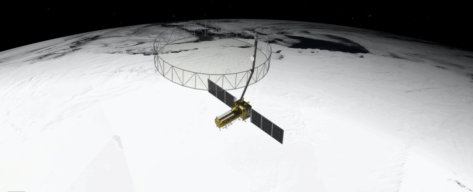
The NASA-ISRO Synthetic Aperture Radar (NISAR) Mission—the first joint satellite mission for the two agencies—launched this morning from India’s Satish Dhawan Space Centre.
The orbiting radar observatory will unroll a 12m wide antenna and begin mapping Earth’s land and ice surfaces twice every 12 days, for at least three years.
Big picture: NASA says this is its most advanced radar satellite, and the first time a spacecraft has carried SAR payloads in two different bands. The two sensors will combine to collect precise measurements of the planet’s surface, and detect changes smaller than a quarter of an inch.
The public dataset will provide Earth scientists with new insight into threats such as earthquakes, landslides and volcanos; changes in the Antarctic ice shelves; and coastal erosion.
Many researchers “don’t yet realize how much of a game changer the NISAR is going to be for them,” Gerald Bawden, the NASA program scientist for the mission, said this week. “My hope is once people start using NISAR data, that they’re not going to imagine [a] time without NISAR.”

Chip happens: US chipmaker AMD provided the space-hardened chips for the satellite, which is expected to generate 80 terabytes of data each day.
“As the resolution of sensors in space is increasing, you have to do more and more processing on board the satellite to make the most optimum use of the limited downlink bandwidth,” Ken O’Neill, AMD’s space systems architect, told Payload. He added that, because NISAR will operate in two different bands, “essentially, you have to do all that processing twice.”
Commercial angle: Private space radar companies, including ICEYE, Umbra, Synspective, and Capella, tend to focus on the market for defense and intelligence users, which requires responsive tasking and high spatial resolution in more cost-effective vehicles.
Pacific partners: After US scientists recommended that the government pursue an EO radar mission in 2007, NASA looked for an international partner to share the costs of the mission, with ISRO stepping up to the plate in 2014. The pandemic and an antenna re-design delayed the mission’s launch.
The $1.5B projected cost of the mission rivals the reported cost of classified spy satellites. NASA JPL’s contributions include the radar antenna, and L-Band radar. ISRO built the spacecraft, the solar arrays, and the S-band radar, as well as contributing the launch vehicle.

ICEYE Smashes Its Own Revenue Projections
ICEYE’s results reveal a massively successful year for a business in the right place at the right time.
Planet Labs Extends Middle East Space Imagery Restrictions
Planet Labs just proved that dual use doesn’t necessarily mean equal priority.

ICEYE Launches New Deforestation Monitoring Tool
ICEYE just one-upped the Lorax. Instead of speaking for the trees, the SAR satellite manufacturer is letting the trees speak for themselves.
Remondo Unveils Plans for Sub-30 cm Resolution Sat
The company believes it can eventually build, operate, and launch each sat for $2M or less, according to CEO Ido Priel.

The Space Force’s Space Systems Command announced it had selected five companies to develop jamming-resilient satellite comms technology.
The companies selected under the Protected Tactical Satcom-Global (PTS-G) contract include Boeing ($BA), Northrop Grumman ($NOC), Viasat ($VSAT), Astranis Space Technologies, and Intelsat General Communications (now part of SES).
SSC has designated $37.3M for research, development, and testing through the end of Jan. 2026. SSC plans to issue another award next year for the production of PTS spacecraft that can launch by 2028. The total contract is an IDIQ with a ceiling of $4B.
Keep reading