
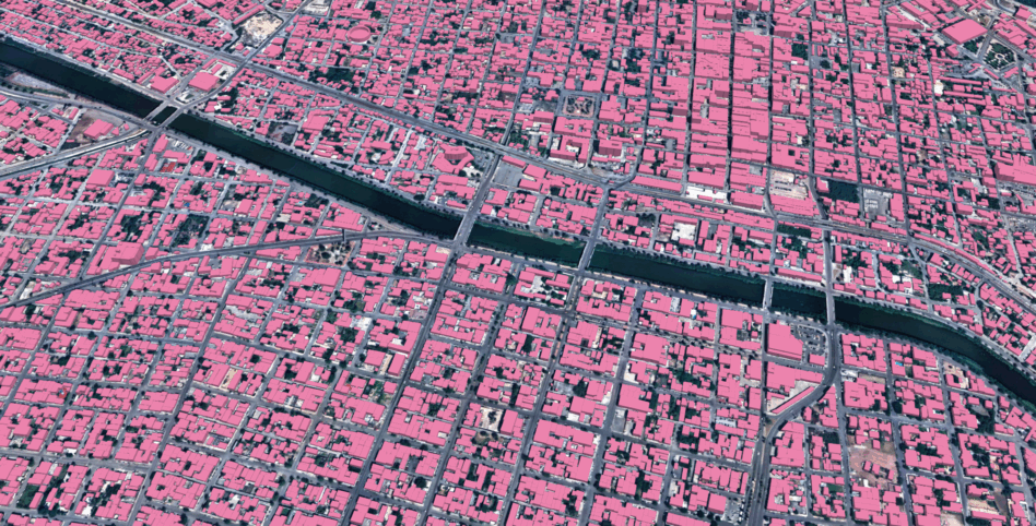
Maxar Intelligence is joining forces with Ecopia AI, an AI-powered mapping company, to build more accurate vector maps that are already being used by government customers around the world.
The problem: Vector maps rely on geospatial data to precisely locate things like buildings, road center lines, and trees. Today, these maps rely on people to update them—a time consuming process.
These maps also face the problem of a “drift” as new imagery updates, making the product less useful over time and potentially falsely flagging anomalies.
The partnership: Maxar and Ecopia AI are launching a production, called Vivid Features, that will pair Maxar’s 30-cm satellite imagery with Ecopia AI’s product to create vector maps that stay accurate over time. Ecopia AI aims to build a “digital twin of the world” using similar high-resolution geospatial data for its vector maps.
The product has already been put to work mapping 1B+ building footprints for US, international, and commercial customers.
“Vivid Features, powered by Ecopia, solves one of the most persistent challenges in digital mapping—the time-consuming process of producing consistent vector map data of every place on Earth,” Peter Wilczynski, Maxar’s chief product officer. “Together, we’ve created a product that eliminates the thousands of hours customers typically spend manually creating and aligning vectors, providing a dynamic basemap suite that maintains fidelity as the world changes.”
Use case: The tech has a variety of use cases, including:
- Helping military operations planners make sure roads and buildings are where they expect them to be;
- Identifying changes accurately in quickly moving scenarios, such as wildfires;
- Tracking illicit activity by spotting new traffic patterns or buildings that pop up.
The tech has already gotten a head start on the latter use case. A Maxar spokesman said Vivid Features has created a “before” picture of Reynosa, Mexico, along the US southern border. That will allow officials to spot unusual container activity or traffic shifts to detect illicit activity earlier than with traditional platforms.

ICEYE Smashes Its Own Revenue Projections
ICEYE’s results reveal a massively successful year for a business in the right place at the right time.

Planet Labs Extends Middle East Space Imagery Restrictions
Planet Labs just proved that dual use doesn’t necessarily mean equal priority.

ICEYE Launches New Deforestation Monitoring Tool
ICEYE just one-upped the Lorax. Instead of speaking for the trees, the SAR satellite manufacturer is letting the trees speak for themselves.

Remondo Unveils Plans for Sub-30 cm Resolution Sat
The company believes it can eventually build, operate, and launch each sat for $2M or less, according to CEO Ido Priel.

A space bill being considered by Congress is directing the defense secretary to look for opportunities to collaborate in orbit with Indo-Pacific allies.
Reps. Jason Crow (D-CO) and Jeff Crank (R-CO) introduced the Quad Space Act last week. A companion bill was introduced in the Senate in June by Sens. Michael Bennet (D-CO) and Kevin Cramer (R-ND).
Context: The Quadrilateral Security Dialogue, better known as the Quad, is a partnership between Australia, India, Japan, and the US. Though the grouping—which is not a formal alliance—got off the ground in earnest in 2017, the member states have grown closer in recent years over their shared concerns about China’s behavior. Leaders of the four nations met for the first time (albeit virtually) in 2021, and have held five summits since then.
Keep reading