
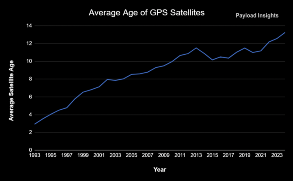
The average age of a GPS satellite is now 13 years, with half of them exceeding their designed lifespan.
The USA-132 satellite broke the record for the oldest GPS satellite in history, having completed 27+ years in operation. While the record is an indicator of the reliability and robust engineering of the GPS satellite, it also means that the service still relies on hardware built in the 1990s.
The Global Positioning System has long been one of the most important and widely-used services in the world but the US navigational network is showing signs of aging, slipping into a pattern of maintaining the status quo rather than driving innovation.
60-sec history: The history of GPS goes all the way back to the world’s first satellite, Sputnik. George Weiffenbach and William Guier of the John Hopkins’ Applied Physics Laboratory found that they could track the satellite’s location by analyzing its radio signal.
This discovery paved the way for the US’s first, but limited, satellite-based geopositioning system, dubbed “Transit,” in the 1960s.
Ever-increasing Cold War tensions drove the military’s need to improve the timing and positioning services, leading to the development of a new and improved version, the Navigation System with Timing and Ranging (NAVSTAR).
NAVSTAR is the GPS system we know today.
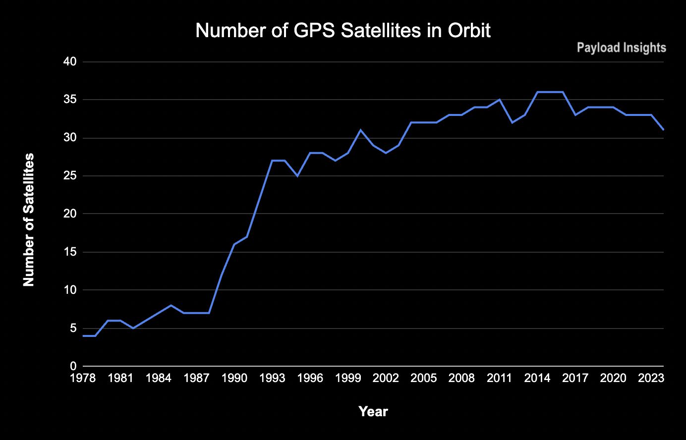
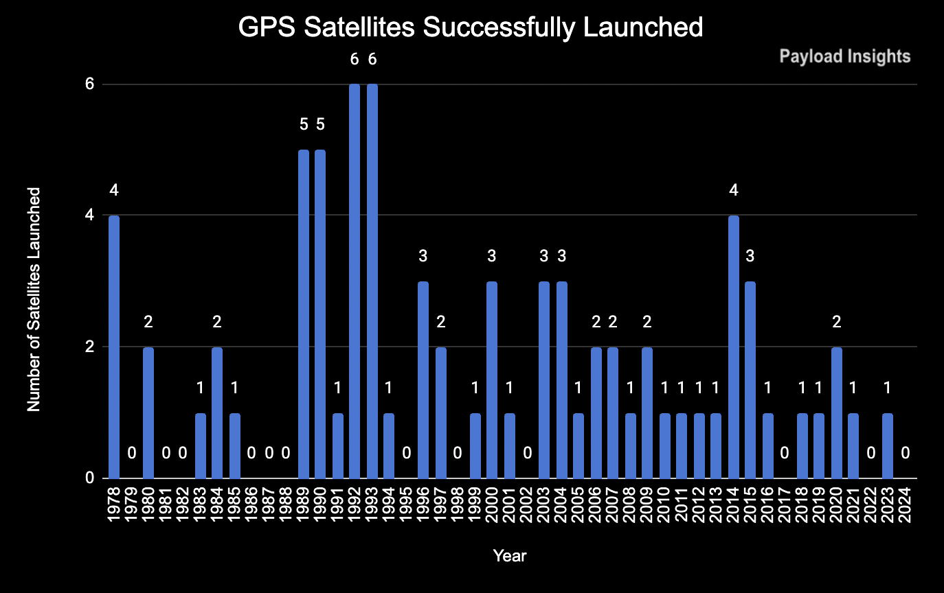
- The first NAVSTAR satellite was launched in 1978, but the system did not surpass the 24-satellite threshold until 1993, when it became fully operational.
- It was designed to offer global coverage by utilizing a minimum of 24 satellites in MEO.
- 31 GPS satellites are in operation today, down from 36 in 2016.
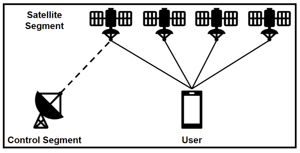
GPS 101: Here’s how GPS works:
- The satellites emit timed radio signals that can be picked up by user equipment
- The equipment uses that signal to calculate the distance between itself and the satellite. By determining the distance between it and four or more satellites, the user’s position can be derived.
Frequency: Each GPS satellite transmits signals in more than one frequency, with L1 and L2 available in all satellites and an L5 frequency offered in the latest generations.
Ground segment: The ground segment is a network of earth stations that track and monitor the GPS satellites, while at the same time keeping track of GPS time.
The Commercialization Era
Originally, the GPS system was primarily designed for military purposes but was opened up to wide-scale civilian use after the tragic accident of Korean Air Flight 007 in 1983.
The Korean Air flight was operating a service between New York and Seoul when the plane deviated from its course, accidentally entering the Soviet Union’s airspace, where it was subsequently shot down.
After the event, President Reagan announced the US would make GPS available to all commercial airliners to ensure no such accident could happen again.
Since then, GPS has grown into one of the most widely used services in the world, with billions of people using GPS on a daily basis today. By many measures, it is the most valuable component of the space economy.
- The service is free for all users equipped with a compatible receiver.
- Civilian GPS applications range from personal devices to transportation and banking.
- GPS time is used across industries to record the time of financial transactions and by the energy sector to synchronize the electricity grid.
- It is estimated that a GPS outage could have an impact of $1B per day.
GPS Modernization
Through the years, the US has modernized both the satellite and the control segment to improve the accuracy and resilience of the GPS service.
Satellite upgrades: For the spacecraft, the changes have focused on adopting stronger signals, increasing autonomous operations, and extending their lifetimes. The most significant recent upgrade has been the introduction of the L5 signal, which required an upgrade to both the satellite and control segments.
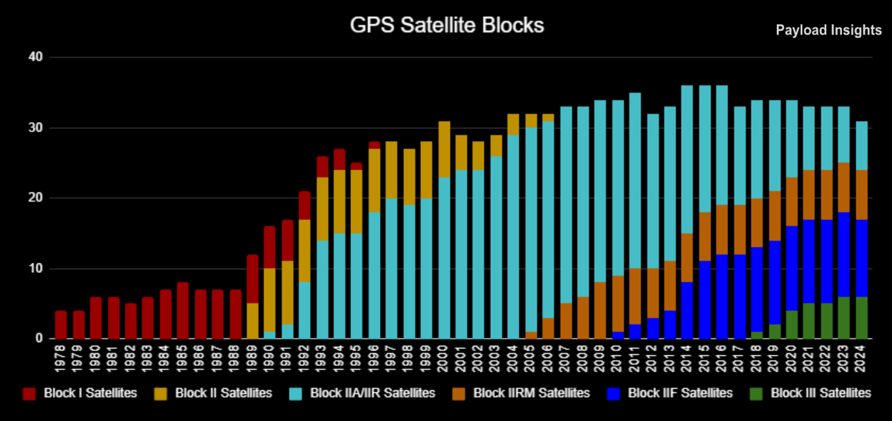
GPS Satellite Upgrades Summarized for Each Block
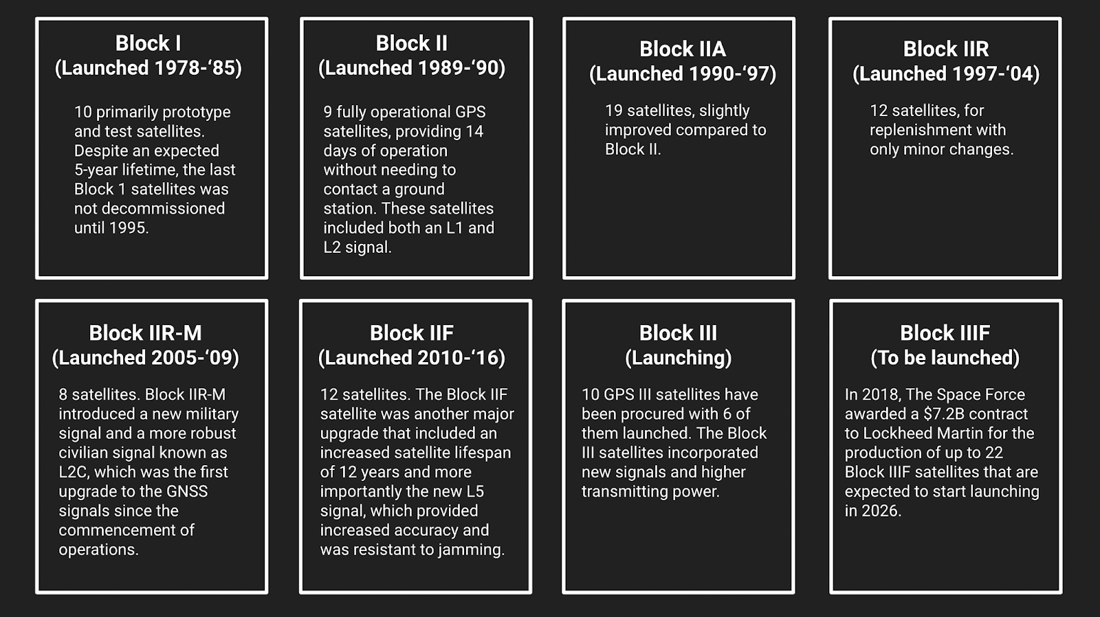
The 10 Block III satellites, alongside the 12 IIF ones, bring the total number of L5-equipped satellites to 22, just shy of the 24 required to declare the L5 signal operational.
The chart below shows the number of GPS satellites each year and their breakdown by block.
Ground segment upgrades: The GPS ground segment is also in the process of modernization effort via the GPS Next Generation Operational Control Segment (OCX). OCX is essential for activating the L5 signal and managing the GPS Block III satellites.
The phase 0, 1, and 2 OCX contracts were awarded to Raytheon (RTX) starting in 2010, and had a target 2016 completion date.
Phase 0 has since been delivered, but the rest of the system is now 8 years late.
Due to the delay, the Space Force created the “GPS III Contingency Operations” program for a software update to existing systems so that the GPS III satellites could operate until OCX is delivered. The government asked Lockheed to develop a software upgrade that would allow the GPS III satellite to operate using the existing infrastructure.
Enter Stagnation
The delay in the OCX ground control program is just one of the issues that have surfaced with the GPS system. Another problem is that the US delayed the launch of new and improved GPS Block 3 satellites.
- In 2021, Lockheed Martin and the Space Force declared three GPS III satellites (SV06-SV08) “ready to launch,” but three years later, only one has launched, while two remain in storage. The next launch is not expected until early 2025.
- The last two GPS III satellites from the 2018 contract (SV09 and SV10) were delivered by Lockheed Martin in late 2022 and early 2023, but they are not expected to launch before 2026.
The GPS satellite launch rate has severely slowed down in the last couple of years, with only 6 satellites launched in the last 8 years. The assets cost hundreds of millions each and are slowly losing their value sitting on the ground.
A game of this or that: Experts suggest budgetary prioritization has become a factor. The GPS continues to work well enough, so if the government can delay launching a satellite with upgraded capabilities, it opens up dollars for other project priorities.
“The government has money to launch GPS,” Todd Walter, director of the GPS lab at Stanford, told Payload. “But I think they look at that money and say I don’t have to spend it on launching these satellites.”
The result is that the government has fallen into a cadence of launching for replacement.
“The current status is launching on need rather than launching to keep moving forward,” said Walters. “Currently the oldest satellite in orbit is over 26 years old, so that’s quite a long time to have a satellite up there.”
The delays in launching GPS III satellites have increased the average age of the GPS constellation. And now their average age has exceeded the design life of many of the satellites.

New satellites need to be launched so older satellites with outdated technologies can be retired, and to minimize the risk of faults that could lead to a temporary system outage.
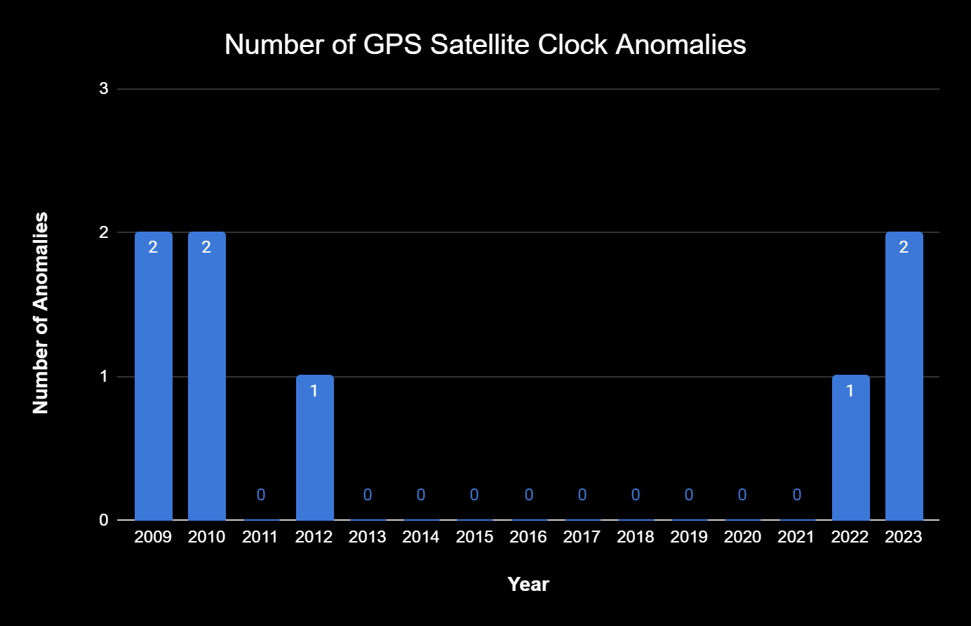
Publicly available data from the Stanford GPS Lab shows that from 2009 to 2023, eight satellite clock errors occurred. Five errors occurred between 2009 and 2012, with no errors reported in the following ten years. Two recent papers from Rebbeca Wang have reported an upward trend in satellite clock failures in the past two years, with one taking place in 2022 and two in 2023.
The overall GPS network still works well. But the aging satellites, coupled with the delays in the OCX program and GPS III launch schedule, threaten its competitive edge as international rivals bring into service their own GNSS systems and private companies develop bespoke alternatives.
Next week: This article will be continued next week, where we will discuss GPS international rivals, jamming and warfare implications, and new commercial entrants.

Juno Propulsion Raises $1.4M Pre-Seed for RDE Flight
The $1.4M pre-seed investment round will fund the completion of its first flight-ready rotating detonation engine (RDE)—called Project Iris—ahead of its inaugural demo mission in 2027.
AstroForge Completes its DeepSpace-2 Spacecraft
DeepSpace-2 will aim to demonstrate the company’s ability to rendezvous with an asteroid and set the stage for future asteroid mining missions before the end of the decade.

Muon Space Unveils New, Larger Satellite Bus
Condor-Ultra is three times larger than its Condor-XL satellite bus, and geared toward the nascent orbital-data-center market.

Northrop Grumman Taps Apex for Golden Dome SBI Collab
Northrop Grumman is on track to deliver on-orbit missile defense capabilities with Apex in 2027.

NASA’s top watchdog published its most scathing report yet on the agency’s management of the Mobile Launcher 2 (ML-2) construction project at KSC.
The Inspector General report, released on Tuesday, describes significant cost and schedule overruns that will likely leave the ground structure to launch SLS unfinished when Artemis IV is scheduled to launch in September 2028.
Repeat offenders: The original $383M contract was awarded to engineering and construction firm Bechtel National in 2019 with the expectation that the launcher would be completed by March 2023.
Keep reading