
The first data from Planet’s hyperspectral Tanager-1 spacecraft has revealed plumes of invisible, climate-altering gas, the non-profit that financed its development said.
Carbon Mapper is developing a global methane monitoring service to track a major contributor to climate change. By spotting leaks and sharing the data, the organization hopes regulators and businesses will be able to work together to reduce emissions, and researchers can better understand how methane affects the planet.
PPP? You know me: The organization raised $130M to facilitate a public-private partnership between NASA JPL and Planet that transferred spectrometer technology from the government to the private sector—something that wouldn’t have been possible just a decade ago.
“Carbon Mapper has a public good mission to make the methane data available, and Planet as a public benefit corporation is aligned with that,” Carbon Mapper CEO Riley Duren, a former JPL engineer, told Payload. “They also want to be able to develop commercial revenue, and we want that because we’re looking to that commercial revenue to enable Planet to build out the constellation so that this isn’t something that philanthropy is funding forever.”
Pull it down: The new sensor detects 400 spectral bands, compared to the three that your eyes can see, or the eight tracked by sensors on Planet’s SuperDove satellites. Robert Green, a JPL researcher who collaborated with Planet, said Tanager-1’s sensor is among the most advanced on orbit.
“The Tanager data cube is a very different beast,” Troy Toman, Planet’s chief product officer, said— and his developers had to build out the infrastructure to downlink, prepare, and deliver that information to Carbon Mapper and, eventually, all kinds of users.
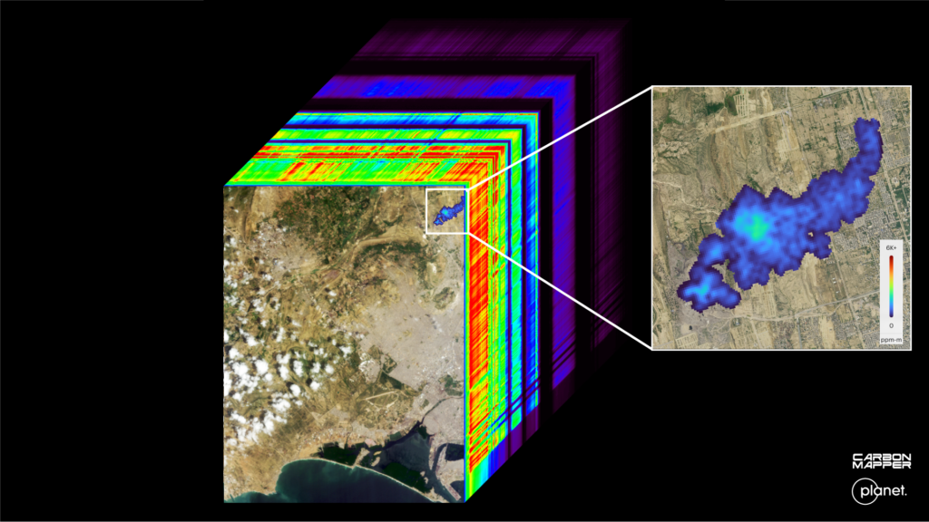
“We’ve kind of been oversubscribed in terms of the early access program, and we’re excited to be able to get that data into more hands,” Toman said. The satellite is still in commissioning mode and needs to be lowered to its operating orbit, a process that won’t be complete until early next year.
Planet and Carbon Mapper plan to build at least one more Tanager spacecraft, tentatively sometime in 2025, Duren said.
Hawkeye 360 Files For IPO
The space-based RF data and analytics firm is the latest in a string of defense-focused space companies seeking to go public, opening access to more capital as the industry grows.

Albedo Ratchets Up the Power for its Second VLEO Flight
Albedo announced a new VLEO capable satellite bus today that’s aiming to fly the company’s second orbital mission in 2027.
Moog’s “Tip to Tail” Contributions to the Artemis II Flight
“Moog supplies more than 100 different pieces of hardware that go from tip to tail of the rocket, [and] into the Orion system.”

Vantor Unveils New Sat Classes: Vantage and Pulse
Vantor introduced two new satellite classes today that will aim to improve on the company’s imagery resolution and revisit rate.
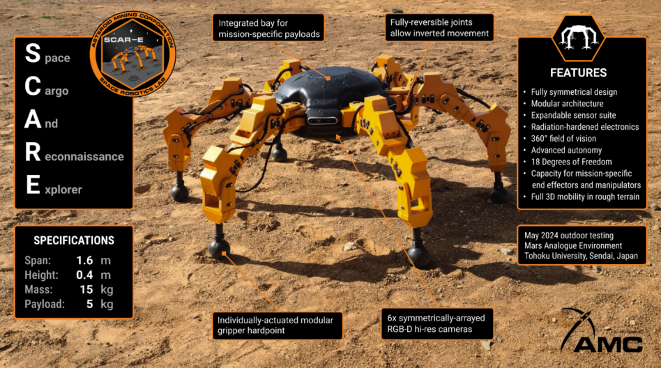
Japanese lunar firm ispace has partnered with Asteroid Mining Corporation (AMC), a UK-based space robotics company, to deliver a space robot to the lunar surface, the two companies announced yesterday.
The mission to put AMC’s Space Capable Asteroid Robotic–Explorer (SCAR-E) on the lunar surface is intended to prove out the company’s ability to extract resources in deep-space.
ispace is building its own lunar rovers to traverse the Moon, but it is also committed to building up the industry more broadly to foster a sustained lunar economy.
Keep reading