
Amid climate change and rising waters, Floodbase is seeking to use space data to streamline the flood insurance process, reducing the load for insurers and getting money into people’s hands for damages more quickly.
Origin story: Floodbase cofounders Beth Tellman and Bessie Schwarz met while pursuing a master’s degree at Yale around the same time as Hurricane Sandy doused the East Coast, leading to record flooding.
Google asked their class to come up with a use case for the newly launched Google Earth Engine, which aggregated petabytes of satellite imagery. Tellman, who had spent the prior four years working disaster relief in El Salvador, saw immediately that Earth Engine represented the largest, most comprehensive flood mapping dataset available.
The pair won the competition, and Floodbase was born in 2015—at least in a preliminary version that the cofounders presented at Google’s Mountain View, CA HQ.
“The company, in a way, sort of built itself. We would present this idea at conferences, and people kept offering us money,” Tellman, now the chief science officer, told Payload.
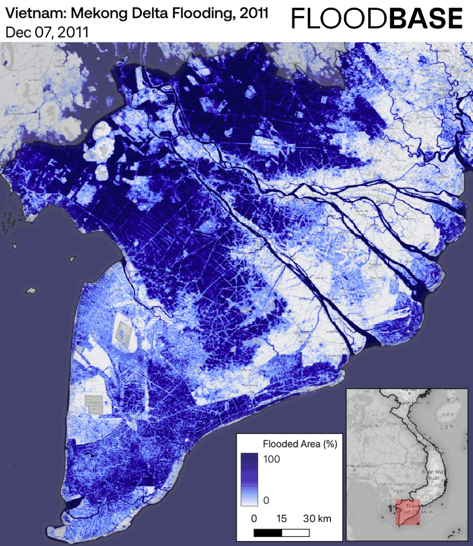
Data, data, data: The company aggregates imagery from up to 15 satellites in orbit, including high-res imagery from Planet and radar from Capella Space, which can detect water levels through cloud cover. The company also utilizes data from the US Geological Survey, the National Water Model, and physical hydrology models to ensure there are no gaps in their coverage.
All of this data is then merged together with machine learning and AI, allowing the company to create a detailed and accurate flood map anywhere in the world.
Floodbase maps have proved invaluable for the UN and national governments to improve their flood disaster response. The company initially worked with aid agencies in communities that are prone to flooding, but soon realized that its data could be used to increase the access to risk financing in these underserved parts of the world.
The Insurance Floodscape
Floods are the most common natural disaster around the world. As flooding has become more frequent and costly due to climate change, risk averse insurance providers have run for the hills.
Despite the National Flood Insurance Program’s attempts to provide more coverage in the US, only 30% of homes in the highest risk areas are protected against flooding, according to The University of Pennsylvania.
Insurance 101: Traditional indemnity flood insurance is simply too expensive for providers to maintain broad coverage in areas where flood risk is high. Indemnity insurance requires an adjuster to assess any damage in person, and payouts are often followed by litigation, which drains the resources of insurance providers and policy holders alike. Tellman estimates that 50-60% of the cost of traditional insurance comes from these litigation fees.
As a result, many parts of the world have been left without any coverage options.
A new way of doing business: To solve this problem, Floodbase offers insurance underwriters and reinsurers a more economically viable way to provide coverage, through parametric insurance policies.
Parametric policies are contracts written with a pre-agreed-upon payout for the policyholder based on detailed flood mapping, which Floodbase provides. These policies remove the costs of adjusters and lower the possibility of litigation, so that both the policyholder and the insurance provider benefit from the lower costs.
These insurance policies have lowered risk premiums and allowed for insurers to offer coverage to underserved parts of the world. “You can cover large areas, farms, municipalities, entire countries. Any land-based asset whose land cannot be covered by traditional indemnity flood insurance or where it’s too expensive to do so,” Tellman said.
Parametric insurance also gives insurers the ability to cover business interruptions from flooding, which was previously impossible under indemnity coverage. If the road to a business is flooded, that business can collect on its insurance policy to stay afloat while the water subsides, all without any input from the insurance provider or the policy holder.
What’s next: Floodbase is always on the lookout for more data to improve its coverage and accuracy. As more EO satellites enter orbit, with sensors detecting new optical wavelengths, Floodbase maps will improve in their accuracy, Tellman said.
The company is also looking to fold other flood sensing technologies, including drones and weather balloons, into their dataset.
SatVu Raises £30M to Accelerate its Constellation
SatVu’s plans for the new capital are twofold: accelerating deployment of its HotSat constellation, and fulfilling demand from across the market.

OroraTech’s New Exec Plans to Step on the Gas
With Zuleta as a catalyst, OroraTech aims to grow to a few hundred sats in the coming years, with the aim of providing worldwide coverage, 15-minute revisit rates, and resolution as low as 50 m.
NRO Awards Contracts to Three Remote Sensing Companies
The contracts, announced on Tuesday, are intended to allow the intel agency to access multiple remote sensing phenomenologies from EO to RF and beyond.

Airbus Taps Skynopy for Pléiades Neo Ground Stations
The European space market may be dominated by large A&D primes, but the startup community is proving it still has an edge when it comes to innovative tech.
The new hardware being built in Silicon Valley from spacecraft to flying cars is about what you can’t see.
“Look at the bill of materials for a modern machine—50% of its software,” Sift CEO Karthik Gollapudi told Payload.
He and co-founder CTO Austin Spiegel, both former software engineers at SpaceX, are developing tools like those they used at the world-leading space company to help other hardware firms work more efficiently.
Keep reading