

The US’ central weather-tracking agency has commissioned BAE Systems to build an instrument for its next-generation weather and climate constellation, GeoXO.
Under the contract, BAE Systems will build a hyperspectral imager that will be fine-tuned to observe the Great Lakes and the US coastal regions. The company is now contracted to provide all three of the hyperspectral instruments for the GeoXO program.
Weather: The Next Generation: Across the US civil spacefaring agencies, including NASA and NOAA, there are a handful of weather monitoring satellites and small constellations in operation today.
- Arguably the most important of these for standard climate and weather tracking is the GOES (Geostationary Operational Environmental Satellites) program, which provides imagery as well as temperature, wind speed, and solar activity data.
- The most recent set of satellites in this constellation, GOES-R, began launching in 2016, and the final satellite in the series, GOES-U, is expected to launch this summer.
- GOES-R is set to reach the end of its nominal mission in the early 2030s.
But the GOES suite of satellites doesn’t cover everything that NOAA wants to be able to do to keep track of the Earth’s changing climate and weather patterns. The agency is developing its own weather-tracking satellites via the GeoXO program, which will allow it to understand Earth’s atmosphere and oceans in more granular detail.
Ocean color is BAE: The color of watery regions as seen from space can reveal a lot of information about the state of the environment, including details about water quality, ocean biology and chemistry, and ecosystem changes, per a release.
The instrument BAE Systems is building, sensibly called the Ocean Color Instrument (OCX), will provide public data at higher resolution and frequency than what’s available today.

Q&A With Lunar Base Manager Carlos Garcia-Galan
At the start of last week, Carlos Garcia-Galan was working on NASA’s program for a lunar-orbiting habitat. Last Tuesday, however, he became the person overseeing the space agency’s ambitious plan to build a lunar surface base at record speed. During last week’s Ignition event at NASA HQ, Payload sat down with Garcia-Galan, the program executive…

Jared Isaacman Hits 100 Days In Office With a Bang
NASA Administrator Jared Isaacman has one message: Get in, we’re going to the Moon.

NASA Priorities Get a Major Makeover
NASA Administrator Jared Isaacman had a vision for a robust, commercially driven lunar economy, supported by surface infrastructure. Now, he also has a plan.

Isaacman Plans Monthly Uncrewed Lunar Landings In 2027
“We are going to plus up for Moon base construction in a huge way,” said during an interview with Spaceflight Now that was released late Friday night.
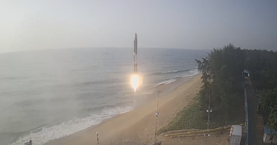
Agnikul Cosmos, an Indian rocket startup, successfully launched its Agnibaan SOrTeD vehicle on a suborbital test flight mission Wednesday, marking another win for the Indian space sector that has already had a banner past 12 months.
“All the mission objectives of this controlled vertical ascent flight were met and performance was nominal,” the company wrote in a statement posted to X.
The demo mission featured a single-stage rocket using a 3D-printed semi-cryogenic Agnilet engine, an important milestone as the company inches toward its maiden orbital launch.
Keep reading