

Converting terabytes of data gathered by ~200 EO spacecraft into useful information isn’t easy, but Planet Labs said its latest product will smooth the way for new Geographic Information System users and data-hungry AI alike.
Analysis Ready Planetscope (ARPS) will process Planet’s daily imagery to make it easier to use for in-depth analysis over time. The tool will scrub out the inconsistencies that come from different sensors, weather, and observation angles, and harmonize images with widely-used satellite datasets like LandSat and SENTINEL—you can check out examples here.
“It’s just a lot of that basic data prep work that we were hearing was interfering with people’s ability to quickly learn the things that they most cared about,” longtime Planet vet Troy Toman told Payload in his first interview in his new role as chief product officer.
Platform planning: This kind of pre-processing is common for advanced consumers of GIS data, but can be daunting to new users, such as “a civil government who may be building some of their first applications,” Toman said.
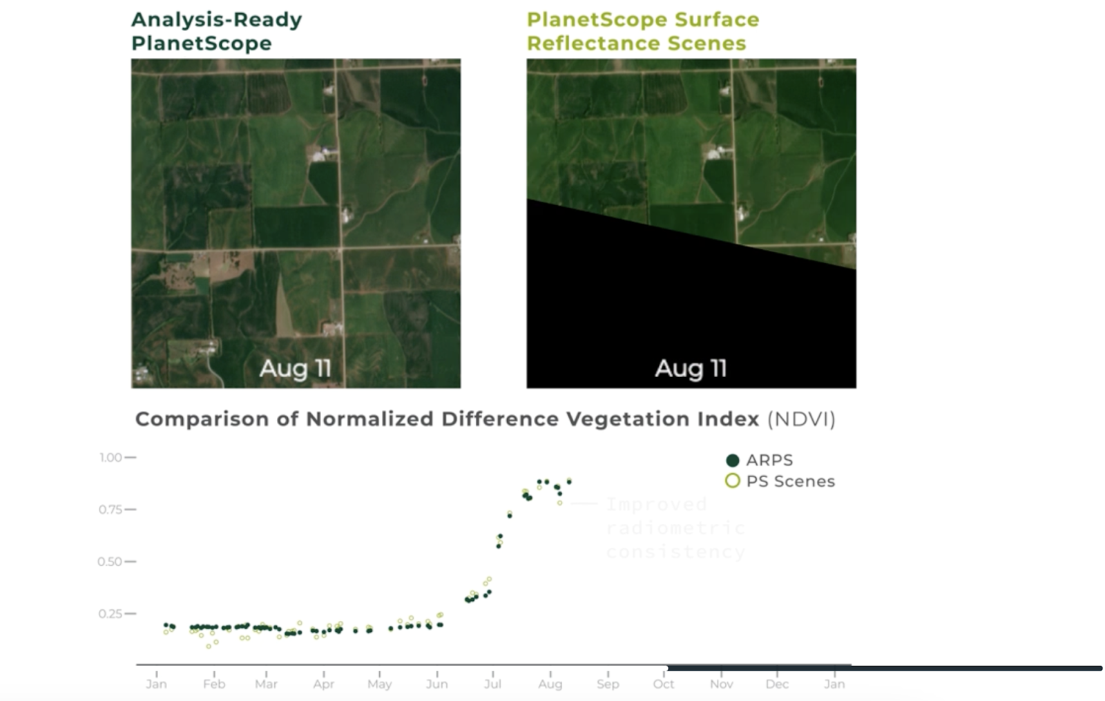
The prep can also smooth the way for machine learning, thanks to the consistent radiometry across the ARPS product and widely-used training data.
“That is a big driver for this, both for traditional algorithms as well as more sophisticated either machine learning type modeling, or even some of the newer Gen AI models, we believe we’ll see better results using this,” Toman said.
The business of space data: Planet has been working to expand its commercial and civil business, a tricky product for a market where selling into defense and intelligence is the easy answer.
“We describe ourselves now as a platform company, which is, how do we put the scaffolding around the satellites and data that we have that make them more accessible?” Toman said.
One customer set investors will watch closely are agridata companies working to make satellite observations useful to farmers. Oryzativa, a Uruguayan firm that works with rice growers across South America, has been beta testing the ARPS product alongside Planet.
“We significantly reduced our error-rate percentage on biomass growth modeling after moving to ARPS from Landsat and Sentinel data and we’re excited to continue using ARPS to help improve the accuracy of our models,” Oryzativa’s CTO Joaquin Peraza said in a statement.
Hawkeye 360 Files For IPO
The space-based RF data and analytics firm is the latest in a string of defense-focused space companies seeking to go public, opening access to more capital as the industry grows.

Albedo Ratchets Up the Power for its Second VLEO Flight
Albedo announced a new VLEO capable satellite bus today that’s aiming to fly the company’s second orbital mission in 2027.
Moog’s “Tip to Tail” Contributions to the Artemis II Flight
“Moog supplies more than 100 different pieces of hardware that go from tip to tail of the rocket, [and] into the Orion system.”

Vantor Unveils New Sat Classes: Vantage and Pulse
Vantor introduced two new satellite classes today that will aim to improve on the company’s imagery resolution and revisit rate.
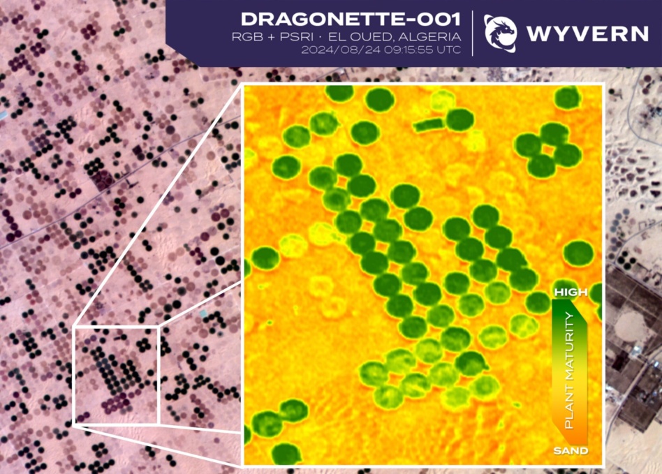
The only company selling hyperspectral data from space on the open market announced a $6M fundraising round this week, led by Squadra Ventures with participation from Uncork Capital and Y Combinator.
Wyvern, the Edmonton, Canada space data firm that has amassed $16M in private capital, gathers data from three satellites with hyperspectral sensors.
The company expects three more spacecraft to launch in the next 18 months, and is focused on expanding to the US market, adding to its 36-person team, and developing novel deployable optics.
Keep reading