
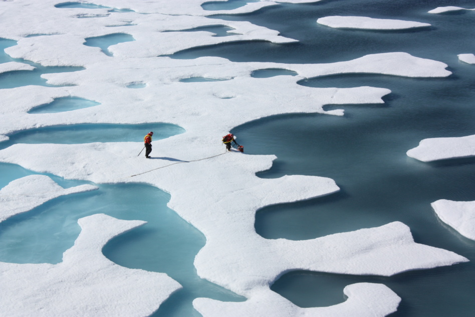
Each year, seawater in the Arctic freezes, melts, and re-freezes with the changing of the seasons. And each year, brave researchers trek out into the cold to stick poles into the snow and float buoys on the sea to measure just how thick that ice is.
Why not just measure the ice thickness with satellites?
In-situ vs. on-orbit
To be sure, a few satellites do provide radar data over the polar regions. In the winter, when the ice and snow are dry and frozen solid, these satellites can record accurate readings of the ice. But in the summer, when the snow melts and forms pools of water on top of the ice, the satellites are blinded by the brilliant reflection off the water. That means they can only gather accurate data for about half the year.
A study published last week in Nature addresses how researchers could fill in the gaps in Arctic ice thickness data and make it trackable via satellite throughout the year.
The researchers used data from ESA’s CryoSat-2, a science mission that records data with synthetic aperture radar (SAR) and an altimeter, to develop a machine learning model to accurately measure the thickness of Arctic sea ice year-round.
“These beautiful ponds of meltwater that sit on top of the ice surface look amazing, but it’s difficult for our radars to properly measure that,” Jack Landy, lead author of the paper, told Parallax. “Basically, these ponds provide a really strong blinding response to the radar.”
Why measure the ice?
Reasonable minds—and ML models—disagree on the variance of Arctic ice change over the course of the next century. That delta, in part, is due to the lack of high-quality summer data.
Better summer data would help to improve those models, giving climate researchers a better understanding of climate change’s effects at the Earth’s outer edges.
“Now that we’ve produced this dataset, there’s a chance to actually calibrate the models against a better or more comprehensive dataset,” Landy said. “And maybe we can narrow down some of these projections for how the ice is going to change in the next decades.”
When it comes to seasonal forecasting, there are commercial applications for accurate sea thickness measurements, Landy said. One example: Shipping companies want to steer vessels through the Arctic regions, so they’re very interested in accurate ice thickness forecasting.
A kink in the data
The CryoSat-2 satellite’s SAR sensor sends a microwave signal down to the Earth, which reflects off the target area and back up to the satellite.
“As that radar pulse comes down from our CryoSat-2 satellite and hits cold, snow-covered ice, it tends to scatter and reflect the energy in many directions,” said Landy. “When it hits the ocean, the ocean acts like a bit of a mirror to it, and it just reflects all of that energy straight back to the satellite.”
The ponds of meltwater dazzle the satellite in the same way the ocean does, keeping CryoSat-2 from distinguishing between the two.
Building the algorithm
Landy and his team have been working for years to figure out how to fill in these yearly gaps in the data. They began by combing through CryoSat-2 data since 2011 and classifying images of water based on whether they depicted the ocean or ponds on top of ice. Using these images, the team trained an algorithm to spot the differences between meltwater ponds and the ocean.
The algorithm also pulls in information from related datasets, including data about the roughness of the ice and thickness of the snow on top, to produce its estimates of ice thickness.
Up next…
Right now, the program that the researchers developed takes several months to produce data. This is in part because of the many layers of data cleaning and the slow analysis of auxiliary data needed for the algorithm to come up with an accurate measurement. The next step for the team, Landy said, is to find ways to cut down on that lead time.
There’s also the issue of CryoSat-2 itself. The mission is already on borrowed time, and operating about eight years past its nominal lifetime. The ESA mission is currently the only satellite equipped with both the radar and altimeter instruments needed for the program to work. Other satellites tend to use one or the other. A follow-on mission, ESA’s CRISTAL—short for Copernicus Polar Ice and Snow Topography Altimeter—is scheduled to launch in 2027.
Keep on chugging, CryoSat-2!
This story first appeared in Payload’s science newsletter, Parallax. Subscribe to Parallax here.

Turn Down the Lights
Nearly every black hole in the universe has a black hole at its center, providing the axis around which the galaxy stars and gas and dust rotate.
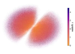
Astronomers Map the Universe’s Quasars
Humans have been mapping the cosmos since the dawn of civilization, but modern technology has allowed scientists to build an entirely new kind of universal chart.
The Hubble Tension Gets Tenser
The universe is expanding—that much is certain. How quickly it’s expanding, though, is still up for debate.
Just Keep Breathing
Jupiter’s moon Europa creates enough oxygen every day to keep a million people breathing—but that’s less than researchers used to think.
What do you get when Planet, Microsoft, and the Nature Conservancy walk into a bar? Probably some pretty wonky and in-the-weeds convos, but also, the potential for a productive collab.
To that end, the three organizations have just lifted the wraps on the Global Renewables Watch (GRW). They describe the tool as “a first-of-its-kind living atlas” for mapping and measuring the world’s utility-scale solar and wind farms. GRW is powered by Microsoft’s cloud and AI tools, which will use Planet’s satellite imagery as its inputs. The Nature Conservancy brings specialists and subject matter expertise to the table.
Planet says that GRW builds on established, peer-reviewed scientific approaches. GRW piloted the atlas by mapping solar and wind in Germany and India, and creating solar maps of Brazil and Egypt. The first full global edition drops early next year.
Keep reading