
Tomorrow marks 100 days since Russia began its invasion of Ukraine.
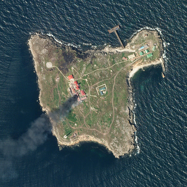
Over the course of the last few months, satellite imagery has served as the world’s window into the destruction and tolls of war, providing vital intelligence that the Ukrainian and allied governments and humanitarian groups have used to defend the country and ease human suffering.
Planet’s Snapshots newsletter chronicled the information we’ve gained from satellite imagery over the past few months. In a Q&A with open-source researcher Wim Zwijnenburg, interspersed with Planet satellite shots, the newsletter goes into the great power—and great responsibility—that comes with wielding satellite imagery for military intelligence:
“In the wider debate, OSINT analysts should be careful on what they publish, in particular around the privacy of civilian victims, as this can be misused or hard to remove once it’s online,” said Zwijnenburg. “Also, they have a responsibility to be really thorough in their publications, as information spreads fast.”
For Payload’s part…We’ve been closely following the role that OSINT via satellite imagery has played in the war so far. In the beginning, the Ukrainian government’s need for commercial satellite imagery quickly became apparent, and the commercial EO sector quickly rose to the challenge, agreeing to freely provide Ukraine with imagery.
Since then, numerous companies have begun initiatives to make it easier for Ukraine and allies to access this imagery, spanning from user-friendly data portals to a fundraising campaign to help Ukraine operate its own EO constellation.
The upshot: This is the first major conflict where public satellite imagery has played a vital intelligence role. The ability to see directly into the war zone has cut through the fog of war to counter false claims about what’s really happening on the ground.

Leonardo’s Missile-Defense Demo in Ukraine Aims To Be a Blueprint for Other Nations
Leonardo is positioning itself to become a mass distributor of space-enabled missile defense shields.

A Recap of Payload’s Space Stage
Two days. Nine panels. Two dozen speakers—and that’s just the space content.

ICEYE Smashes Its Own Revenue Projections
ICEYE’s results reveal a massively successful year for a business in the right place at the right time.

Q&A With Laurent Jaffart, ESA’s Director of Resilience, Navigation and Connectivity
Jaffart is leading the charge to build up ESA’s defensive posture. Payload chatted with him to hear his plans for the new role.
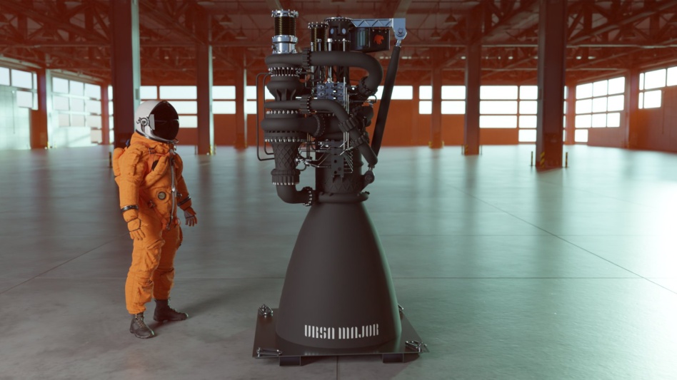
Render of Ursa Major’s Arroway heavy-launch engine. Image: Ursa Major.
Ursa Major has unveiled its engine for heavy launch vehicles. The Colorado startup is calling its latest propulsion product Arroway, a nod to Dr. Ellie Arroway, Jodie Foster’s character in Contact.
Arroway specs: 200,000-pound thrust, liquid oxygen and methane staged combustion, mostly 3D printed, and reusable.
Keep reading