
Last Wednesday, in the lead-up to Russia’s full-scale invasion of Ukraine, we wrote about how commercial satellite imagery laid bare the open secret of Moscow’s military mobilization.
Satellite imagery has contributed to a growing corpus of open-source intelligence (OSINT) analysis, a vital asset helping to pierce through the fog of war. Newsrooms, analysts, and amateur sleuths have tapped satellite imagery to supplement social media posts, on-the-ground reporting, and word-of-mouth updates from the war, now in its fifth day.
What can space-collected data tell us about the conflict?
A partial list:
- Troop movement
- Invasion into new territories
- Continuity or disruption of critical infrastructure
- Flows of displaced peoples/refugees
- Military buildups in neighboring countries and the wider region
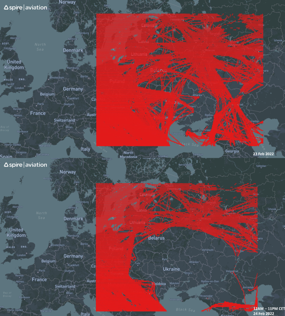
- Where commercial vessels and airliners are operating
It’s just not just traditional satellite imagery that can play a part in OSINT analysis.
As we noted last week, with synthetic aperture radar (SAR), “‘seeing’ through wintry conditions/cloud cover and following ground-level changes is no problem.” Spire’s radiofrequency sensors show maritime vessel movements and air traffic flows. Finally, GPS data from Google Maps has showed traffic jams that correspond with civilians evacuating from Kyiv and Russa military vehicle movement.
Satellite-collected information can be used both as 1) a primary, straightforward source of information or 2) proxy, alternative data.
- Charred airfields, cratered city suburbs, and armored column convoys tell an uncomplicated story about the conflict. And satellite imagery appears to show the destruction of AN-225 ‘Mirya’ (translation = dream), the largest plane in the world. Ukraine confirmed that Mirya was destroyed.
- Seen from space, the thermal readout of an energy plant wouldn’t be enough in and of itself to determine why it was still operational or offline.
Industry dynamics
“The conflict in Ukraine and its global implications create an opportunity for the new Earth observation space companies to demonstrate their capabilities,” Cognitive Space CEO Scott Herman told SpaceNews. “You don’t get a better opportunity than this to show how remote sensing can support media storytelling and help with the general public’s understanding of a crisis like Ukraine.”
- It’s easier for established companies with predictable revenue streams to freely share information, he noted, versus upstarts that have yet to monetize their offerings.
- We’d add that companies with larger LEO constellations and more rapid revisit rates are better equipped to readily share data/imagery.
Takeaway: Joe Morrison, Umbra’s VP of product and friend of Payload, summed it up nicely via tweet: “Suddenly a couple billion people are really interested in satellite imagery and maps.”

Intel Authorization Act Proposes Limiting Commercial EO Access
EO data is a privilege, not a right, and the US government wants to control what EO satellite operators can and can’t share with the public.
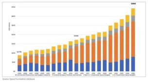
Breaking Down the $686B Space Economy
The global space economy totaled a record $686B in 2025, according to the Space Foundation.
DoD Adds $11.4B to NatSec Launch Contracts
The DoD upped its ceiling for national security space launches on Friday, more than tripling the pool of NSSL launch contracts from $5.6B to $17B.

NatSec Space Policy Nominees Face Questions from Senators
The Pentagon’s nominee to lead space acquisition said the military’s legacy space programs weren’t built for the modern acquisition reforms now reshaping the Space Force.

Users in Ukraine have reported that Viasat KA-SAT internet service is down in the country, and the outage has spread to other countries in Europe. The likely culprit: a Russian cyberattack on the morning of Feb. 24.
Viasat announced Monday morning that it’s consulted cyber experts to investigate the outages. In a statement, the company said it believed the outages were linked to “a cyber event.”
Right now, along with investigating the root cause of the issue, Viasat says it is working to restore connectivity to its European customers.
Keep reading