
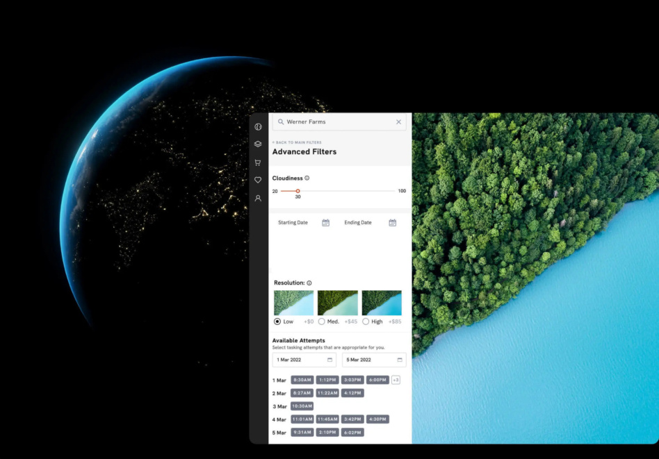
SkyFi believes that satellite imagery should be easily accessible and affordable for anyone to access. Today, the Austin, TX startup took a major step toward democratizing that data with the public launch of its mobile and web apps.
The story so far: SkyFi built an entirely new app and interface for individuals to task satellites and buy archival images. SkyFi’s app, it says, is the first consumer-focused satellite imagery purchasing platform.
“No one likes to talk to a salesperson, exchange emails, get a custom quote, and wait for them to approve your use case or imagery,” Luke Fischer, CEO of SkyFi, told Payload. “That’s not democratizing access, that’s bottlenecking access. For us, we want to make it as painless as possible.”
The company has raised $10M so far to develop its app, and it launched a beta version in September.
- Roughly 1,300 people signed on to be beta testers.
- Of that group, 25% converted, so to speak, and made accounts.
- SkyFi’s curated cohort of testers largely included individuals who are proficient in the dark arts of buying satellite imagery, but it also included total newcomers.
Feedback from the newcomers in particular led to simpler language and improved educational resources on the website, Fischer said.
Open for business: Within twelve taps—they counted—users will be able to order a brand-new satellite image from the Skyfi app. Electro-optical and multispectral imagery is available from any of the company’s 16 data partners.
Transparent pricing, Fischer said, is core to the company’s values. “There should be no smoke and mirrors about how much it costs,” he said.
- Existing satellite images start at $20.
- Tasking a satellite to capture a new image starts at $175.
Keep an eye out…SkyFi is developing an analytics layer that users can purchase alongside imagery. The startup has partnered with nine analytics providers to make that happen.

Reflex Aerospace Taps Arkadia Space for 2027 Mission
Reflex Aerospace selected Spanish startup Arkadia Space to provide a propulsion system for its satellite mission, launching in 2027.

NewOrbit Raises $18.5M to Build VLEO Spacecraft at Scale
While NewOrbit has yet to fly in any orbit, the company is targeting a first flight of its VLEO-capable NEO-1 satellite in 2028.
Juno Propulsion Raises $1.4M Pre-Seed for RDE Flight
The $1.4M pre-seed investment round will fund the completion of its first flight-ready rotating detonation engine (RDE)—called Project Iris—ahead of its inaugural demo mission in 2027.
AstroForge Completes its DeepSpace-2 Spacecraft
DeepSpace-2 will aim to demonstrate the company’s ability to rendezvous with an asteroid and set the stage for future asteroid mining missions before the end of the decade.

Through 60 Minutes, Congress, and incremental declassification, American citizens have been treated to a closer look into what the US government’s “aliens(???)” desktop folder looks like.
Driving the news: The intelligence community’s (IC) quest to understand elusive UFO-esque unidentified aerial phenomena (UAP) sightings has borne fruit. Those fruits, though, don’t offer any conclusive evidence of aliens. (At least, that’s what the declassified UAP report offers.)
Yesterday, the Office of the Director of National Intelligence (ODNI) released an unclassified report on its investigation into UAP reports made over the last 17 years across the nation. The ODNI combed through analysis from the various agencies that make up the US intelligence community.
Keep reading