
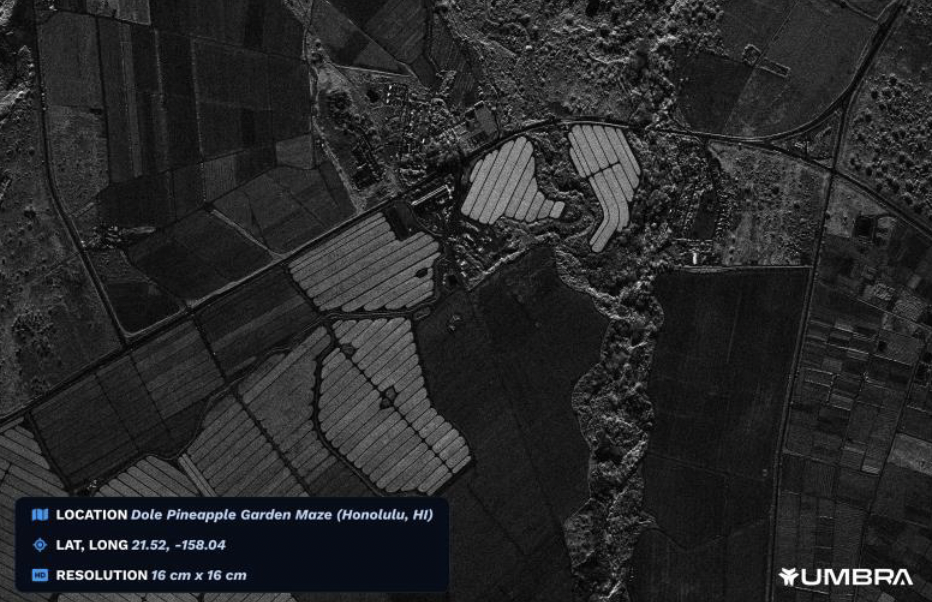
Commercial space imaging hit a new resolution high-water mark.
Satellite operator Umbra released a 16 cm/pixel Synthetic Aperture Radar (SAR) image today, making it the highest-res commercial satellite image ever dropped, according to the company. The image is comparable to the resolution that was previously restricted to government use.
“This means that we are finally able to offer customers the highest resolution images that our satellites are capable of capturing, setting the stage for even further expansion of products to customers,” said Umbra president Gabe Dominocielo.
Evolving regulations: The US began permitting the sale of commercial satellite images only a few decades back, but still restricted super-high res imaging—like the 10-cm picture Trump tweeted in 2019—to government use only.
Over the last few years, NOAA has started loosening commercial imaging restrictions, allowing satellite operators to innovate and expand further into various end markets and use cases. Umbra was able to release today’s 16-cm image as a result of NOAA recently loosening its 25-cm restriction on the Santa Barbara-based company’s commercial imaging.
Umbra 101: Umbra operates six SAR satellites, serving the US government (50% of revenue), allied nations (25%), and commercial customers (25%). Unlike optical imaging, Umbra’s SAR radars are not dependent on light, allowing them to deliver high-resolution images around the clock and in all weather conditions. The company has contracts from the NRO, Air Force, and DARPA.

Space Stocks Dip After SpaceX IPO
SpaceX’s strong first day out was coupled with a significant pullback among investors in other publicly traded space companies, sending major players down across the board.
VCs Predict the SpaceX IPO Will Lift the Entire Industry
After the public markets initiate their newest whale, what happens to the rest of the space industry still reliant on private capital?
Exclusive: Tilebox Launches AI-Focused Update
Tilebox announced an update today aiming to make AI agents more effective geospatial-data analysts.

Analysts Debate SpaceX’s $1.75T Valuation Ahead of IPO
Analysts are split over whether that’s the right number, and how the stock will perform in the short term—but everyone agrees the space industry is booming.

Wait your turn, room-temp superconductor. We’re still not finished with the AI craze.
NASA and IBM launched their open-source geospatial foundation model on the AI platform Hugging Face, the team announced yesterday. The model leverages NASA’s vast inventory of satellite data to provide insight and modeling on the impacts of climate change.
“We believe that foundation models have the potential to change the way observational data is analyzed and help us to better understand our planet,” said Kevin Murphy, NASA’s chief science data officer.
Keep reading