Since GPS became operational in 1993, the US has been far and away the leader in satellite navigation technology. But the landscape is rapidly changing, and international alternatives are catching up.
The average age of a GPS satellite is now 13 years old. The oldest satellite has been in operation for 27 years, a time when Blockbuster was booming, cell phones were clunky bricks, and Google was still called ‘BackRub’ (just learned that odd tidbit).
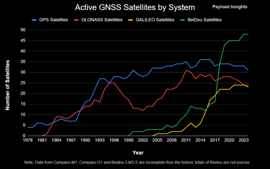
GPS network upgrades have been hampered by delays and an overall budgetary deprioritization. In the meantime, international rivals have charged ahead— China’s BeiDou Global Navigation Satellite System (GNSS) now has more sats than the GPS constellation.
The rise of international GNSS rivals
The four big players in global GNSS tech are the US, Russia, EU, and China.
GLONASS (Russia): The GLONASS navigation network commenced operations in 1995 and is designed to have a minimum of 24 satellites in orbit for full coverage. Due to Russia’s geography, the network focuses on offering reliable service in higher latitudes, where GPS signal acquisition can be challenging.
- GLONASS dropped below the critical number of 24 satellites in 1997.
- Russia did not restore the system until after 2010 when the government reprioritized the program due to its importance in modern warfare.
Galileo (EU): The Galileo GNSS program began early operational capability in 2016, with fewer than 24 satellites in orbit. Currently, 23 satellites are operational, and an additional two are under commissioning.
- Contrary to other navigation systems, the EU primarily designed the service for civilians rather than military purposes.
- In 2018, Galileo received FCC approval for its signals to be used in the US.
BeiDou (China): The Chinese BeiDou system launched its basic global service in 2018 and has roughly 48 active satellites in orbit and an additional two under commissioning. A minimum of 30 satellites are needed for global operations. The satellites are spread out in multiple orbits, increasing diversification.
The chart shows the number of satellites of each GNSS constellation, starting in 1978 with the launch of the first GPS satellite.
The newer BeiDou and Galileo tech offers a few advantages over the aging US GPS system.
Galileo accuracy: Galileo launched its High Accuracy Service (HAS) in 2023, targeting position accuracy of 20 cm horizontally and 40 cm vertically. The EU pronounced that the service is the most accurate in the world.
However, GPS remains more resilient, and the Galileo system is still incomplete, with only 23 satellites operational compared with the designed 24+6 constellation. The EU has committed funding for Galileo Gen 2, which is slated to begin launching in 2026.
China’s innovation: The largest competitive threat to the GPS system is China’s BeiDou. The Space-Based PNT Advisory Board put it bluntly in its 2023 summary report saying, “GPS’s capabilities are now substantially inferior to those of China’s BeiDou.”
The network’s satellites are younger than GPS and utilize a more advanced ground segment with a larger number of monitoring stations.
BeiDou also features technologies that GPS lacks, such as two-way messaging.
- The capability can provide critical communications in remote areas with no infrastructure and can also be used for surveillance purposes by relaying back data from a user’s device.
- The technology can provide an edge for autonomous applications and “smart” infrastructure, by integrating the ability to monitor them across the world.
GNSS systems in the age of electronic warfare
The armed conflicts in Eastern Europe and the Middle East have shed light on the Achilles heel of GNSS—their low-powered signals. Electronic warfare in the form of jamming is an easy way to disable GPS-guided ammunition and drones, by blocking the GNSS satellite signals.
Israel has reportedly employed spoofing, a technique of broadcasting fake GNSS signals, in surrounding areas to disorient enemy GNSS-guided missiles. For example, GPS spoofing can identify a target to be located at Beirut’s international airport, despite actually being hundreds of miles away.
The effects of jamming and spoofing are experienced even miles away from the battlefields by civilian use cases such as commercial aviation. GPS loss in flights over Europe or the Middle East has become a more common occurrence. Flightradar24, as seen in the figure below, has launched an interactive map where GPS-denied areas can be seen.
New signals: The US government developed the L5 signals to address, in part, GPS’s vulnerability to jamming. However, only part of GPS’s aging satellite fleet has that capability due to OCX and GPS III launch delays.
Galileo and BeiDou networks have already incorporated and operate L5-like signals.
Multi-system access hardware
Modern GNSS receivers, especially those in smartphones and low-power electronics, have the ability to pick up and use signals from all four GNSS systems. This capability has significantly increased their position accuracy due to the greater availability of satellites.
Multi-system access receivers have raised questions in the US, as the Glonass and BeiDou systems are not licensed for use in the country. Both Apple and Android phones are capable of receiving BeiDou’s signals; however, software adjustments in Android phones disable their use within the US. It is unclear if Apple products use the BeiDou signals within the US.
In other regions of the world, like Africa and Southeast Asia, GPS is losing its dominance, pushing countries to rely more on China’s BeiDou system. With every country that integrates BeiDou instead of GPS as a primary GNSS network, the US influence fades away to new Chinese technology.


