
JAXA tapped ArkEdge Space, a Tokyo-based nanosatellite company, to study the feasibility of putting a Position, Navigation, and Timing (PNT) constellation in LEO, the company announced yesterday.
ArkEdge has won multiple JAXA contracts and has worked on a navigation and comms system for the Moon. In this contract, the company is hoping to show that operating a Global Navigation Satellite System (GNSS) closer to Earth can vastly improve the terrestrial applications of PNT data.
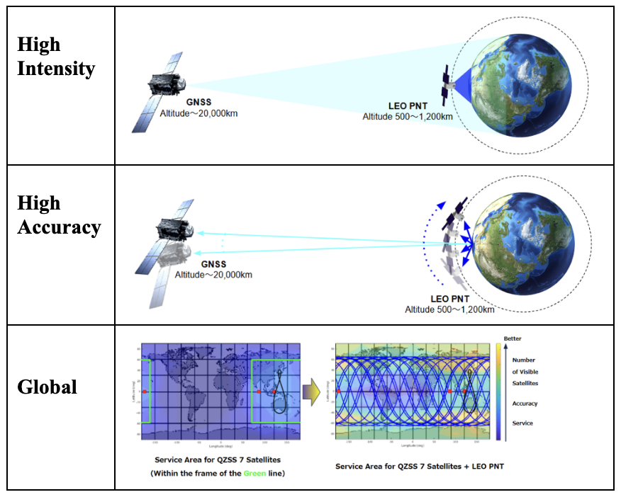
The theory: While conventional GNSS satellites operate ~20,000 km over Earth, the proposed PNT constellation would fly substantially lower, between 900-1,200 km. ArkEdge expects this proximity would deliver a wide range of benefits:
- Intensity: A LEO PNT constellation would send stronger signals than conventional GNSS PNT satellites to provide more reliable positioning information that’s less prone to jamming and spoofing.
- Accuracy: Satellites in LEO experience a more dramatic angle of change in location over time. To the positioning signal receiver back on Earth, this means that data will be faster and more accurate.
- Global coverage: A constellation in LEO can cover and revisit a larger surface area of the globe than those at higher altitudes, and coverage can expand quickly if new satellites are deployed.
Methods: ArkEdge is undertaking a broad study to show the benefits of a LEO PNT system, and examine what it might look like when it comes time to test it.
- The company will assess the trade-offs of having a LEO PNT system in the form of a constellation, and evaluate the GNSS signal generated by satellites in LEO.
- ArkEdge will also attempt to determine the signal format and frequency bands the constellation should use, and lay out a conceptual design of the eventual PNT demonstration mission, proposing the number of satellites, their design, and where they should fly in orbit.
Bigger picture: Ultimately, the LEO PNT system aims to support terrestrial industries as they move toward greater automation. If the constellation provides more accurate PNT data as expected, it would help autonomous cars and agricultural machines to be safer and more effective, while increased reliability and accuracy would unlock new use cases for PNT data on Earth and in orbit.

What the SpaceX IPO Means for Europe’s Space Industry
All eyes are on New York today for SpaceX’s IPO, but the moment represents more than just a record-breaking exit by a US space company.
Bellatrix Aerospace Tapped to Build Korean VLEO Demo Sat
Bellatrix Aerospace is teaming up with Korean optical payload manufacturer TelePIX on a new VLEO demo satellite, launching NET 2028.
ESA Chief Calls on Europe to Double Funds for Space
Europe has made huge strides increasing public funds to grow its space economy, but to some in the industry, enough is not enough.

NASA-Funded Research May Create Chinese Security Risk, Report Says
NASA has potentially funded or supported hundreds of scientific collaborations since 2015 that might involve Chinese researchers, a new Congressional report says.
A Jackal rendezvous and proximity operations spacecraft will launch on a Firefly Alpha rocket in 2025 to participate in the Space Force’s VICTUS HAZE demonstration mission, True Anomaly said today.
True Anomaly is building a spacecraft to perform an RPO demo in tandem with another vehicle being built, launched, and operated by Rocket Lab. True Anomaly’s Jackal will be integrated into an Alpha fairing at Vandenberg and remain on hot standby until receiving a 24-hour launch notice from the Space Force to head for orbit.
“Firefly is the only company that has the performance that we need to perform that mission,” True Anomaly CEO Even Rogers said. “You need something to get a particular package, to the right place, the right time—and they had the experience.”
Keep reading