
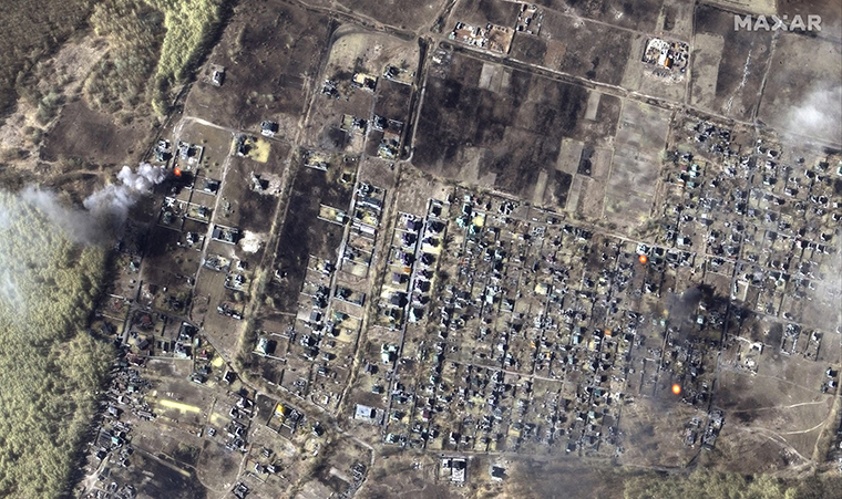
Imagery shows destruction of a neighborhood in Moschun, Ukraine. Satellite image ©2022 Maxar Technologies.
Satellite imagery is continuing to prove a trustworthy source and rare window into the tolls of war. New Maxar imagery shows massive destruction by Russian attacks across Ukraine, as well as the movement of Russian military forces.
The damage: Ukraine’s cities have sustained devastating damage from Russian missiles in the past three weeks. In Moschun, a city about 34 miles northeast of Kyiv, Maxar imagery shows that nearly every house in a residential neighborhood was scorched and severely damaged. Damage is visible to hospitals and commercial and residential areas across Ukraine, particularly in Mariupol, Chernihiv, Sumy, and Kharkiv.
The imagery also shows the movement of Russian troops and artillery. Maxar captured a line of Russian self-propelled howitzers and multiple rocket launchers stationed outside the city of Chernihiv, as well as Russian ground forces deployment at an airfield in Kherson.
Satellite imagery takes the spotlight: Last night, Maxar images of Mariupol and areas near Kyiv were CNN online’s top story when we looked around 10pm ET. At SXSW, Umbra co-founder Gabe Dominocielo recently said the demand for satellite imagery of Ukraine is 4X greater than what existing commercial Earth observation satellites can fulfill, SpaceNews’s Jeff Foust tweeted.
For their part, satellite imagery companies have been stepping up and providing Ukraine with satellite imagery to support the defense of their country.
- Satellogic and Astraea last week created a platform to get free satellite imagery to Ukraine and humanitarian groups.
- Canadian satellite developer MDA is supplying SAR imagery.
- Maxar, Planet, and Capella Space, among others, have said they are working with the Ukrainian government to provide imagery.
One-On-One With SDA’s GP Sandhoo
It’s been about six months since the SDA launched its first operational tranche of satellites—but troops still aren’t benefiting from the better comms tech because of a series of small issues that forced the agency to take a “strategic pause,” SDA Acting Director Gurpartap “GP” Sandhoo told Payload.

Leonardo’s Missile-Defense Demo in Ukraine Aims To Be a Blueprint for Other Nations
Leonardo is positioning itself to become a mass distributor of space-enabled missile defense shields.

A Recap of Payload’s Space Stage
Two days. Nine panels. Two dozen speakers—and that’s just the space content.

ICEYE Smashes Its Own Revenue Projections
ICEYE’s results reveal a massively successful year for a business in the right place at the right time.
After months of delays in Congress, POTUS has signed the FY22 Consolidated Appropriations Act, which funds the federal government through the end of September. The bill introduces some changes into funding levels for NASA, NOAA, and USSF for the next year (ahem…six months).
Here’s our rundown of those changes.
The agency is slated to receive $24B in federal funding, a 3.3% YoY increase but still $760M short of the amount requested. A few major updates:
Keep reading