
Today marks the six-month anniversary of Russia invading Ukraine.
Over the last half year, space-based services have played an integral role in each step of the conflict. Today, we’re providing a partial accounting of how space-based services and hardware have altered the course of the conflict (and how the space industry has itself been changed). In many cases, satellite imagery and communications have helped Ukraine hold its ground against Russia…both on the battlefield and in the court of global public opinion.
The before times
Prior to Russia officially kicking off its “special military operation,” commercial satellite imagery laid bare Moscow’s military buildup in Belarus and Russia’s own border with Ukraine. Newsrooms, think tank analysts, and OSINT researchers trawled through this imagery to track:
- land clearing
- field hospital construction
- elevated aerodrome activity and aircraft deployments
- equipment transporters
- …and much more.
American military and reconnaissance satellites were tracking the same thing, in more granular detail, but that imagery was classified and only shared on a need-to-know basis. As we wrote one day before the invasion:
“Commercial satellite imagery has enabled those with the know-how to essentially become intelligence analysts, no security clearance needed. What was once private can now be shared for the world to see in plain sight.”
Feb. 23
The outbreak of war in eastern Europe
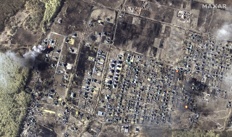
In the first and foggiest days after the outbreak of war, the need for timely, high-resolution optical satellite imagery quickly became eminent. Ukraine Vice Prime Minister Mykhailo Fedorov called on commercial EO companies to supply the country with up-to-date imagery. By all appearances, the space industry has worked to answer that call.
Optical imagery wasn’t the only way that on-orbit assets shaped the early days of the conflict.
- Capella Space’s synthetic aperture radar (SAR) readouts showed the startup’s customers what Russia’s military was up to under the cover of clouds or night.
- NASA’s heat-seeking and wildfire detection satellite data has helped to reveal shifting front lines of the conflict.
- Spire’s ADS-B sensors, meanwhile, picked up international airlines scrambling to route around Ukrainian airspace, and Kyiv-bound passenger planes turning around, in the hours leading up to Russia’s invasion. Before- and-after timestamped images from Spire show ADS-B signals from commercial aircraft in Europe, on Feb. 23 vs. 24. The maps of these signal readings tell a straightforward story: Ukraine’s airspace closed, in anticipation of something ominous.
On Feb. 24, a wide-ranging cyberattack knocked thousands of satellite communications (SATCOM) users on Viasat’s network offline. The US intelligence community later attributed the attack to Russia’s military. The attack was one of, if not the most destructive hack related to the ongoing war. The wiper malware used in the attack effectively bricked the KA-SAT modems of tens of thousands of European customers (presumably including Ukraine’s military).
The conflict reaches space
In response to Russia’s aggression in Ukraine, the US and Europe enforced sanctions that began to impact relations in space. ISS became a bargaining chip, with then-head of Roscosmos Dmitry Rogozin threatening to pull out of the partnership unless sanctions were lifted. Still, throughout the bluster and threats, NASA maintained that business on the ISS would continue as usual. And Roscosmos hasn’t given any formal notice that it intends to imminently walk away from the space station agreement.
The space industry at large also felt the impact of the war. Right away, Europe lost access to Soyuz launches, leaving multiple projects—including ESA’s ExoMars lunar rover mission and OneWeb’s broadband constellation—stranded. The world also lost access to rocket engines and components, including the Russian-built RD-180 and RD-181 rocket engines and the Ukrainian-built first stage of Northrop Grumman’s Antares rocket.
- The world’s largest cargo aircraft, Mriya, was destroyed in the war. Many of Ukraine’s Antonov cargo planes were grounded in the country, leaving some spacecraft to find other rides to the launch site.
- Ukraine and Russia were also top suppliers of noble gasses, which are commonly used as propellants for satellite thrusters. Supply of theses gasses has dramatically draped off during the war.
A harsh new reality sets in
Satellite imagery continued to play a huge role in the conflict, with photos shot from space splayed across social media, cable broadcasts, and the top stories on international media outlet’s home pages.
Starlink received outsized recognition, and for a time was one of the most downloaded apps in Ukraine, as Kyiv pleaded with SpaceX to ship terminals into the country and the company answered the call. Rightfully so, Russia suspected that Starlink would have dual-use (civilian and military) applications in Ukraine. Russia has repeatedly attempted “cyberwar jamming & hacking attempts” against Starlink, per Elon Musk.
- “We’re ready, even if there is no light, no fixed internet, through generators using Starlink, to renew any connection in Ukraine,” Ukrainian vice prime minister Mykhailo Fedorov told Politico in June.
In late March, Iridium CEO Matt Desch told us usage of the company’s satcom services had grown by ~50X in Ukraine since the war started. “Demand for all of our products there has outstripped supply,” Desch said, with surging interest in satellite phones, push-to-talk devices, and other mobile tracking and specialty broadband hardware.
As the war continued, multiple aid initiatives sprung up to ease the tolls of war and grant Ukraine some agency. Hawkeye 360 and NSSA partnered to raise humanitarian aid funds, and HFX began a campaign to buy Ukraine a dedicated satellite constellation.
And last week, the Serhiy Prytula Charity Foundation signed an agreement with ICEYE to give Ukraine access to an operational SAR satellite over the region.
In sum…
- Satellite imagery has pierced through the fog of war.
- Satcom kept Ukraine’s leadership, military, and civilian population connected.
- Commercial space players are experiencing a coming of age moment, due to surging demand for their products.
- Behind the scenes, Washington and Western governments are still in the driver’s seat, tasking satellites, purchasing imagery, and distributing it to partners.
- Geopolitical instability provoked by the war has led the US and its allies to rapidly increase aerospace and defense budgets.

NatSec Space Policy Nominees Face Questions from Senators
The Pentagon’s nominee to lead space acquisition said the military’s legacy space programs weren’t built for the modern acquisition reforms now reshaping the Space Force.
Spinifex Space Launches With Australian Test Ranges
Spinifex Space will provide end-to-end suborbital launch campaigns, private range access, and test and evaluation (T&E) infrastructure.

Pulse Space Lands $40M Space Force Contract to Develop Laser Tech
Pulse Space, a WA-based startup building laser systems capable of beaming power to other satellites on orbit, announced a $40M Space Force contract.

NATO Allies Plan to Stitch Together Sovereign Space Fleets
Eight NATO allies announced plans this week to combine their national defense satellites into a single network.

A new space station has moved one step closer to reality. Yesterday, Blue Origin and Sierra Space announced that their Orbital Reef project has passed its system definition review for NASA. The orbital outpost is now ready to enter the design phase.
The ISS is destined for a watery grave in 2030—or even before that—and NASA is working with space agencies and a handful of industry partners to ensure the US doesn’t lose its sustained access to LEO.
Led by Blue and Sierra, Orbital Reef is one of three space station concepts that NASA has funded through its Commercial LEO Destinations (CLD) program. Amazon Supply Chain, Amazon Web Services, Arizona State University, Boeing, Genesis Engineering Solutions and Redwire Space are also working on the project.
Keep reading